Rare Books
West Indische Paskaert waerin de graden der breedde over wederzÿden vande middellÿn waßande soo vergrooten dan die aeproportioneert syn seger hunne nevenstaende graden der legende; Vertenen (behalven Europaes zudelÿeste alle de Zeekusten van Africa en America begrepen in't Octroy bij de H. M. H. Staten generael der vereeniende Nederl., verleent aende generale West Indische Compagnie. Mitsgaders die van Peru en Chili, inde groote Zuyd-Zee / Beschreven door Willem I. Blaeuw

You might also be interested in

West Indische Paskaert : In veel plaetsen verbetert ende vernieut near verscheÿden Stuerluÿden haer ondervinding die deze kusten. Bezeÿlt en bevaren hebben
Rare Books
"Vertronen (behalven Europaes zuÿdelÿcste) alle de Zeekusten van Africa en America, begrepen in’t Octroy bÿ de H.M.H. Staten generael der vereeinichde Nederl. verleent aende generale West Indische Compagnie. Mitsgaders die van Peru en Chil. Inde groote Zuÿd Zee." Printed on vellum. To the right is Africa and Europe north to Amsterdam. Inserted within Africa is the southern extension of the African coastline to the Cape of Good Hope. The left side showing the Americas has the southern extension of South America as an insert in Brazil. See 439524 for the Blaue map of which this a probable derivative. Differs from the Blaeu's original of 1608 by showing the southwest coast of Africa overlaid on Europe and northern Africa, and the map of the southern portion of South America which is overlaid on Brazil is smaller. Includes more place names along the coasts. Is described as improved and updated (verbetert ende vernieut). See Burden Vol. 1 257; this map is State 1. Relief: no. Projection: Mercator. Printing Process: Engraving.
268067
Image not available
Insulae Americanae in Oceano Septentrionali : cum terris adiacentibus
Rare Books
Florida extends across the Gulf Coast. Lowery states "This map is reprinted with the same title and same plate in Jansson, 1642." Cartouche: reptiles and putti. Dedication: Figures and coat of arms, "Amplmo. prudmo. doctmoque. viro D. Alberto Conradi vander Burch, I.C. Reip. Amsterdamensis Senatori, Collegii Scabinorum Praesidi, Societatis Indicae, quae ad Occidentem militat, aßeßori, et nuper ad Magnum Moscoviae Ducem Legato." Date and publisher are based on language and signature on verso, according to Van der Krogt and Burden. MS notes: Antilles 2+ mat sticker: 1258. Prime meridian: Ferro. Relief: no. Graphic Scale: Miles. Projection: Cylindrical. Printing Process: Copper engraving. References: Lowery, 129; Philips, Atlases, 455; Van der Krogt, map 9600:2B; Burden, map 242. Verso Text: Dutch Atlas text; 4 ; C; MS note: 150053.
150053
Image not available
Nova totius terrarum orbis geographica ac hydrographica tabula / auct. Guiljelmo Blaeuw
Rare Books
Kashnor notes, "Shows the North-West Coast of America stretching away to the 67th degree of latitude, where is the Strait of Anian and the North-Eastern Coast of Asia. Locates Cape Mendocin and the Sierra Nevada Range." Includes a dedication to P.C. Hooft. State 4 of the map according to Shirley (Map 255). Cartouche: Several with figures. Vignettes: Seven wonders of ancient world at bottom; seven ancient Gods at top; four elements left; four seasons right. Sub maps: North and South Polar views. Prime meridian: Ferro. Relief: pictorial. Projection: Mercator. Printing Process: Copper engraving. References: Van der Krogt, map 0001:2A. Verso Text: Des Geheelen Aerdtrycks Beschryving (Dutch).
148961
Image not available
Paskaert waer in de graden der breedde over weder zyden vande middelyn wassende soo vergrooten, dat die geproportioneert syntegen hunne nevenstaende graden der lengde. Vertonende (behalven Europaes zuydelyckste) een gedeelte van de custen van Africa en America, in't Octroy by de H.M.H. Staaten Genl. der vereenichde Nederl. verleent aende Genle. West-Indische Comp. 't Amsterdam by Joannes van Kuelen boeckverkooper en graed-boogh maeker aende nieuwe brug in de gekroonde Lootsman. Met Privil. gie voor 15 Laar
Visual Materials
Kashnor notes, "Shows New Netherland, showing "Nieu Amsterdam ofte nieu Yorck," New London, Long Island, "Noorte Rivier" and Boston ; also shows Newfoundland, New France, part of the West Indies and South America." Kashnor dates as [1695]. Cartouche: colored w. putti and atlas.. Prime meridian: Teneriffe. Relief: no. Projection: Cylindrical. Printing Process: Copper engraving. Other Features: Cartouche. Verso Text: MS note: 501.
093:501 M
Image not available
Kaart Aaanwyzende de Wegen langs welken de Heer Hearne in de Jaaren 1770,1771, en 1772, zyne beide Landtogten gedaan heeft ter ontdekkinge van de Kopermijn Rivier onder't bestuur van de Maatschappy der Hudson's Baai
Visual Materials
Kashnor notes, "A rare map of Hearne's journey to the Coppermine River." Hearne's routes shown in hand color. Prime meridian: GM. Relief: pictorial. Graphic Scale: No. Projection: Mercator. Watermark: Crowned coat-of-arms, Adriaan Rocce. Printing Process: Copper engraving. Verso Text: MS. note: 26.
093:026 M
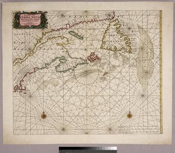
Pas-Caert van Terra Nova, Nova Francia, Nieuw-England en de groote Rivier van Canada. t'Amsterdam, Ny Hendrick Doncker Boekverkoper en Graed booghmaker inde Nieuwbrug Steegh
Visual Materials
Kashnor notes, "Shows the coast from Nantucket to Belle Isle, locating Cape Cod, Boston, Southampton, Plymouth, Aggawom, and other towns in New England. A rare map." Relief: no. Graphic Scale: Miles. Projection: Mercator. Printing Process: Copper engraving. Verso Text: MS note: 462.
093:462 M