Visual Materials
Seat of War in America
You might also be interested in
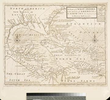
Chart of the West Indies or the Islands of America in the North Sea &c. Being the Present Seat of War. by Herman Moll Geographer
Visual Materials
Kashnor notes, "Shows the mainland around the Gulf of Mexico, with Louisiana, Florida, Georgia, and Carolina." Kashnor dates as ca. 1719. Submap: Vera Cruz harbor. Sailing instructions for galleons. MS note: 321 (on backing). Prime meridian: London. Relief: no. Projection: Cylindrical. Watermark: Two devices. Printing Process: Copper engraving. Other Features: Sub-maps.
105:321 S
Image not available
Map of that part of America which was the Principal Seat of War. in 1756
Visual Materials
Kashnor notes, "Nova Scotia to Massachusetts, and westward to Lake Ontario and the St. Lawrence." Kashnor dates as ca. 1760. RLIN record suggests printing date of 1757. MS note: 661 (on backing). Prime meridian: London. Relief: pictorial. Graphic Scale: Miles, leagues. Projection: Pseudocylindrical. Printing Process: Copper engraving.
105:661 S

A Plan of the Harbour of St. Augustin in the Province of Georgia
Visual Materials
Kashnor notes, "A very rare chart issued for the commanders of ships of war during the Revolution. It shows a very good plan of the city of St. Augustin, with Fort St. Mark and the fortifications. Coloured impressions are very rare." Kashnor dates ca. 1780. Relief: hachures. Graphic Scale: Miles, feet. Projection: Plane. Watermark: Crowned fleur-di-lis J. Bates. Printing Process: Copper engraving. Verso Text: MS note: 991.
105:991 M
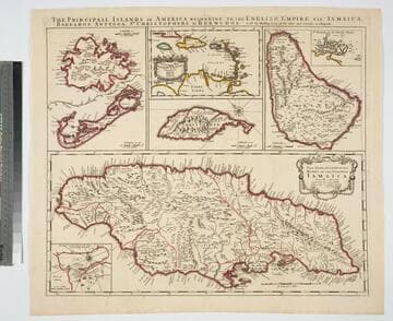
Principall Islands in America Belonging to the English Empire, viz Jamaica, Barbados, Antegoa, St. Christophers, & Bermudos
Visual Materials
Kashnor notes, "Contains one of the rarest maps of Bermuda." Kashnor dates as ca. 1685. Eight maps on one sheet. See 105:190 for later revised version. Eight maps on one sheet.. Relief: pictorial. Projection: Plane. Watermark: H. Printing Process: Copper engraving. Other Features: Sub-maps. Verso Text: MS note: 192.
105:192 M
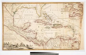
The Seat of the War in the West Indies, or the Islands of America in the North Sea
Visual Materials
Kashnor notes, "Issued during the War of the Spanish Succession, and makes a special feature of showing the tracks of the Spanish galleons. Has the declaration of Moll that the map of Mortier is not correct, he has 'vainly assumed the title of Geographer, tho he understands nothing of a map.' " Opening treasure boxes marked w fleur-de-lis. Submaps: Vera Cruz, Cartegena, Havana, Porto Bello.. "Together with the adjacent Dominions; Explaining what belongs to Spain, England, France, Holland, &c. As also the several Tracts made by the Galleons and Flota from place to place, with other considerable Improvements according to the Newest and best Observations. By Robert Morden & Herman Moll." Relief: pictorial. Graphic Scale: Leagues, miles. Projection: Conic. Printing Process: Copper engraving. Other Features: VignettesSub-maps. Verso Text: MS note: D32.
105:971 L

A new and accurate map of the present seat of war in North America, from a late survey
Visual Materials
Kashnor notes, "A scarce map, issued during the early part of the Revolution." Kashnor dates c.1776. RLIN record places publication in London and appearance in Universal Magazine. MS note: 107 (on backing). Prime meridian: Ferro. Relief: pictorial. Graphic Scale: Miles. Projection: Cylindrical. Watermark: Two seals. Printing Process: Copper engraving.
105:107 S