Visual Materials
Map of North America, showing the places where the Metals, Minerals, Fossiles, and Medicinal Waters are to be found
You might also be interested in
Image not available
A New Map of North America from the Latest Discoveries. 1763
Visual Materials
Kashnor notes, "A good map of the far west to the Lake of the Woods, and locating Fort St. Charles and Fort St. Pierre. Shows the old boundaries of Carolina, Virginia, and New England reaching beyond the Mississippi." MS note: 524 (on backing). Prime meridian: London. Relief: pictorial. Projection: Mercator. Printing Process: Copper engraving.
105:524 S
Image not available
A New and Accurate Map of North America, Drawn from the famous Mr. D'Anville with Improvements from the Best English Maps; and Engraved by R. W. Seale; Also the New Divisions according to the late Treaty of Peace, by Peter Bell Geor
Visual Materials
Kashnor notes, "This map was originally issued by Jefferys in 1755 at the time of the troubles with the French regarding encroachments. It has been brought up to date, but the boundaries of North and South Carolina, Georgia, and Virginia still reach to the Mississippi." Relief: pictorial. Graphic Scale: Miles. Projection: Pseudocylindrical. Printing Process: Copper engraving. Verso Text: MS notes: JO 331.
105:331 M
Image not available
North America From the French of M. d'Anville: Improved with the Back Settlements of Virginia and Course of the Ohio
Visual Materials
Kashnor notes, "A scarce map reduced from Jefferys' map." Kashnor dates as [1755]. This is a reprint of the Jefferys/ Anville map of 1755, see McCorkle 755.2 for other variations. This one is apparently not listed. "R. Cole sculp." Cartouche: flowered. MS note: 640 (on backing). Prime meridian: Ferro. Relief: pictorial. Graphic Scale: Miles. Projection: Pseudocylindrical. Printing Process: Copper engraving. Other Features: Cartouche.
105:640 S
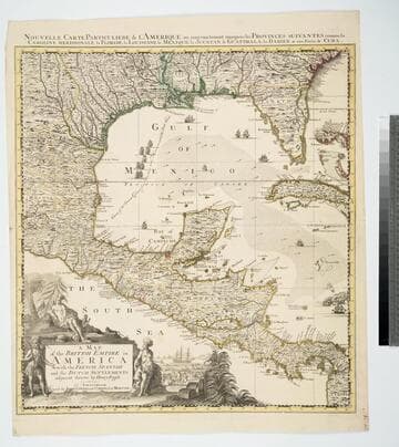
Map of the British Empire in America With the French, Spanish and the Dutch Settlements adjacent thereto by Henry Popple
Visual Materials
Kashnor notes, "Copied from Popple's map With the titles in English and French. ShoWs Carolina divided into counites, With Georgia and the Forts neWly erected, and Savannah." Kashnor dates as ca. 1740, RLIN record suggests 1755. Cartouche of Indians, traders. MS note: No. 10. Relief: pictorial. Projection: Cylindrical. Printing Process: Copper engraving. Other Features: Cartouche. References: McCorkle [741.2]. Verso Text: MS note: 326.
105:326 M
Image not available
A Map of the British and French Settlements in North America
Visual Materials
Kashnor notes, "shewing the French encroachment and forts, and with an account of the English claims to the territories in dispute." Kashnor dates as ca. 1756. RLIN record suggests 1750-59. Cartouche includes Lodge's name. Detailed history of various English colonies. MS note: 622 (on backing).. Prime meridian: London. Relief: pictorial. Projection: Mercator. Printing Process: Copper engraving. Other Features: Cartouche. Verso Text: MS notes: 63 G47.
105:662 S
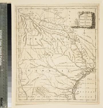
A new and accurate map of the province of Georgia in North America
Visual Materials
Kashnor notes," An old map published about 1775, shewing the roads and Indian paths." Kashnor dates c.1775. Duplicate map to 093:094S, 093:391. RLIN record notes date as [1779?] and place of publication as [London?] and as appearing in The Universal Magazine of 1779. MS note: 103 (on backing). Prime meridian: [Ferro]. Relief: pictorial. Projection: Cylindrical. Watermark: Crowned circular seal. Printing Process: Copper engraving.
105:103 S