Visual Materials
Baye de Chesapeake en 4 Feuilles

You might also be interested in

Riviere et Détroit de D'Awfoskee en Caroline Meridle. par le Cape Gascoigne
Visual Materials
Kashnor notes, "A rare chart of what now is called Callibogue Sound. It was taken from the rare English chart, and issued for the use of French navigators during the Revolution." Relief: no. Graphic Scale: Milles. Projection: Plane. Watermark: Chained Maltese cross lettering. Printing Process: Copper engraving. Verso Text: MS notes: 83 2+.
105:083
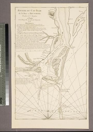
Riviere du Cap Fear de la Bare a Brunswick
Visual Materials
Kashnor notes, "This is copied from Edward Hyrne's chart issued by Jefferys, and was issued for the use of French navigators during the Revolution." Gives sailing directions. Prime meridian: London. Relief: no. Graphic Scale: Miles. Projection: Plane. Watermark: Chained Maltese cross. Printing Process: Copper engraving. Verso Text: MS note: 84.
105:084 S

Port et Barre d'Amelia. de la Floride Orientale
Visual Materials
Kashnor notes, "Issued for the use of French navigators during the Revolution. It is a rare chart, taken from an English chart, showing the location of plantations." This map is a direct copy of Jacob Blamey's map, 105:094. Appeared in per RLIN record. Relief: no. Graphic Scale: Miles. Projection: Plane. Watermark: Chained Maltese cross lettering. Printing Process: Copper engraving. Verso Text: MS note: 101.
105:101 M
![Carte de la Floride Occidentale et Louisiane - La Peninsule at Golfe de la Floride ou Canal de Bahama avec les Isles de Bahama [two maps in one]](/_next/image?url=https%3A%2F%2Frail.huntington.org%2FIIIF3%2FImage%2F22APN4KVPDMF%2Ffull%2F%5E360%2C%2F0%2Fdefault.jpg&w=750&q=75)
Carte de la Floride Occidentale et Louisiane - La Peninsule at Golfe de la Floride ou Canal de Bahama avec les Isles de Bahama [two maps in one]
Visual Materials
Kashnor notes, "Copied from Jefferys' fine chart, the best chart of the time for navigators to Florida and the Mississippi. This was issued for the use of French allies during the Revolution." Appeared in reference from RLIN record. Compass rose. Ships on two routes.. Prime meridian: London, Ferro. Relief: pictorial. Graphic Scale: No. Projection: Mercator. Watermark: Chained Maltese cross lettering. Printing Process: Copper engraving. Other Features: Art Work. Verso Text: MS notes: 28 29 98.
105:098 M
Image not available
New and Accurate Chart of the Bay of Chesapeake
Visual Materials
Kashnor notes, "A rare chart issued for the use of commanders of war-ships and transports during the American Revolution. Engraved on available blank spaces are minute instructions as to sailing into various harbours and the Chesapeake appears to have been of vital importance, for there is no doubt that copies were used during operations around Philadelphia." Submap of Herring Bay in Maryland. [Kashnor's description from 093:441, another copy, probably printed later.] Kashnor states circa. 1770. Submap: Plan of Herring Bay,in Maryland.. "with all the Shoals, Channels, Islands, Entrances, Soundings, and Sailing Marks, as far as the Navigable Part of the Rivers Patowmack, Patapsco and North-East. Drawn from Several Draughts made by the most Experienced Navigators, Chiefly from those of Anthony Smith Pilot of St. Marys; and compared with the Modern Surveys of Virginia and Maryland." Prime meridian: London. Relief: no. Graphic Scale: Leagues. Projection: Plane. Watermark: Crowned fleur-di-lis over IVC VI . Printing Process: Copper engraving. Verso Text: MS notes: 814 5 6.
105:814 M
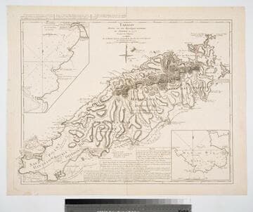
Tobago Dressé sur des Arpentages nouveaux Par Jefferys en 1776. Traduit de l'Anglois A. Paris Par le Rouge Ingineur Geographe de Roi, Rue des grands Augustins. avec Privileged du Roi 1779
Visual Materials
Submaps: Topographie, de la Grands et petite Baye de Courland; Man of War Baye.. Prime meridian: Ferro. Relief: hachures. Graphic Scale: Leagues. Projection: Cylindrical. Watermark: Chained maltese cross lettering. Printing Process: Copper engraving. Other Features: Sub-maps. Verso Text: MS note: 837.
093:837 M