Visual Materials
Riviere et Détroit de D'Awfoskee en Caroline Meridle. par le Cape Gascoigne

You might also be interested in

Port Royal Dans la Caroline Méridionale Levé par le Cape Gascoigne Publié a Londres on 1776 Tradiut
Visual Materials
Kashnor notes, "An exceedingly rare chart, taken from the original English chart, which is also exceedingly rare. This was issued for the use of the commanders of French Ships-of-War and Transports during the Revolution." Relief: no. Graphic Scale: Miles. Projection: Plane. Watermark: Chained Maltese cross lettering. Printing Process: Copper engraving. Verso Text: MS notes: 82 23.
105:082 M

Entrée de la Riviere d'Hudson depuis la Pointe Sandy Hook jusqúa New York les Bancs, les Sondes les Guides &c. Traduit de l'Anglais
Visual Materials
Kashnor notes, "A very rare French chart of New York Harbour, copied from the English chart, and issued for the use of French Allies during the Revolution." Relief: no. Graphic Scale: Miles. Projection: Plane. Watermark: Chained Maltese cross lettering. Printing Process: Copper engraving. Verso Text: MS notes: 13 121.
105:121 M

Port et Barre d'Amelia. de la Floride Orientale
Visual Materials
Kashnor notes, "Issued for the use of French navigators during the Revolution. It is a rare chart, taken from an English chart, showing the location of plantations." This map is a direct copy of Jacob Blamey's map, 105:094. Appeared in per RLIN record. Relief: no. Graphic Scale: Miles. Projection: Plane. Watermark: Chained Maltese cross lettering. Printing Process: Copper engraving. Verso Text: MS note: 101.
105:101 M
![Carte de la Floride Occidentale et Louisiane - La Peninsule at Golfe de la Floride ou Canal de Bahama avec les Isles de Bahama [two maps in one]](/_next/image?url=https%3A%2F%2Frail.huntington.org%2FIIIF3%2FImage%2F22APN4KVPDMF%2Ffull%2F%5E360%2C%2F0%2Fdefault.jpg&w=750&q=75)
Carte de la Floride Occidentale et Louisiane - La Peninsule at Golfe de la Floride ou Canal de Bahama avec les Isles de Bahama [two maps in one]
Visual Materials
Kashnor notes, "Copied from Jefferys' fine chart, the best chart of the time for navigators to Florida and the Mississippi. This was issued for the use of French allies during the Revolution." Appeared in reference from RLIN record. Compass rose. Ships on two routes.. Prime meridian: London, Ferro. Relief: pictorial. Graphic Scale: No. Projection: Mercator. Watermark: Chained Maltese cross lettering. Printing Process: Copper engraving. Other Features: Art Work. Verso Text: MS notes: 28 29 98.
105:098 M

Environs de Philadelphia par Seull et Heap, Publié á Londres par Faden en 1777
Visual Materials
Kashnor notes, " A very rare impression of the French map of Scull and Heap, issued for the use of the French allies in the Revolution." Relief: hachures. Graphic Scale: Miles. Projection: Plane. Watermark: Chained Maltese cross lettering. Printing Process: Copper engraving. Verso Text: MS note: 136.
105:136 M
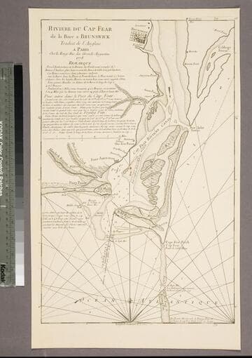
Riviere du Cap Fear de la Bare a Brunswick
Visual Materials
Kashnor notes, "This is copied from Edward Hyrne's chart issued by Jefferys, and was issued for the use of French navigators during the Revolution." Gives sailing directions. Prime meridian: London. Relief: no. Graphic Scale: Miles. Projection: Plane. Watermark: Chained Maltese cross. Printing Process: Copper engraving. Verso Text: MS note: 84.
105:084 S