Rare Books
West Indies. Bonacca Island
Image not available
You might also be interested in
Image not available
A residence in the West Indies and America, : with a narrative of the expedition to the Island of Walcheren
Rare Books
349931

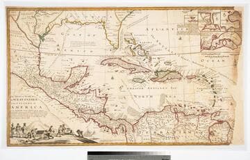
A Map of the West-Indies or the Islands of America in the North Sea
Visual Materials
Kashnor notes, "The map also shows parts of Louisiana and South Carolina, and Central America. It is dedicated to William Paterson, the promoter of the Darien Colony." Kashnor dates as ca. 1720. View of Mexico City. Five submaps. See also 105:328M for another copy. View of Mexico City with building key; Submaps: St. Augustine; Vera Cruz; Havana; Darien; Cartagena.. "with the adjacent Countries; explaning [sic] what belongs to Spain, England, France, Holland &c. also the Trade Winds, and the several Tracts [sic] made by the Galeons [sic] and Flota from place to place. According to the Newest and most Exact Observations by Herman Moll Geographer." "To Wil. Paterson Esq; This map of the West-Indies &c. is most Humbly Dedicated by Herman Moll Geographer." Prime meridian: London. Relief: pictorial. Graphic Scale: Miles, leagues. Projection: Pseudocylindrical. Printing Process: Copper engraving. Other Features: VignettesSub-maps. Verso Text: MS notes: 958.
105:958 M
Image not available
6. An Island Producing Gas Volcano in Trinidad, West Indies
Manuscripts
The collection contains letters, documents, including 190,000 reports, 1200 maps, 500 photographs, and 8200 pieces of printed material related to the life and career of Ralph Arnold. Subjects represented in the collection include: mining, petroleum, and seismology in the Western United States as well as Canada, Mexico, Cuba, and South America; political papers from 1914 to 1956, mostly concerning the campaign of Herbert Hoover for president; family and personal papers from 1836 to 1961 of Arnold and his father, Delos Arnold, containing source material on Pasadena and Southern California local history. The collection also contains Arnold's field books, including those made at Stanford University with the U.S. Geological Survey from 1900 to 1909.
mssArnold

A New Map of the West Indies; or the Islands of America in the North Sea
Visual Materials
Kashnor notes, :Shows the coast of present-day Texas, and locates the Acansa and Teaucas Land, 'The People about this river are continually in Wars with the Spaniards'." Four harbor submaps. Submaps: A Draught of the Bay & City of Havana; The Bay of Porto Bella; A Draught of the Sity of Cartogena, its Harbour & Forts; La Vara Cruz. Cartouche: Soldiers, battle.. " With the Adjacent Parts, Explaining what belongs to England, Holland, Spain, France, &c. Also the Several Tracts made by the Gallions and Flota. by N. Vischer of Amsterdam. Is now done into English with many Considerable improvements according to the Newest and Best Observations." Prime meridian: Ferro. Relief: pictorial. Graphic Scale: Miles, leagues. Projection: Cylindrical. Printing Process: Copper engraving. Other Features: Sub-mapsCartouche.
105:800 M
The Seat of the War in the West Indies, or the Islands of America in the North Sea
Visual Materials
Kashnor notes, "Issued during the War of the Spanish Succession, and makes a special feature of showing the tracks of the Spanish galleons. Has the declaration of Moll that the map of Mortier is not correct, he has 'vainly assumed the title of Geographer, tho he understands nothing of a map.' " Opening treasure boxes marked w fleur-de-lis. Submaps: Vera Cruz, Cartegena, Havana, Porto Bello.. "Together with the adjacent Dominions; Explaining what belongs to Spain, England, France, Holland, &c. As also the several Tracts made by the Galleons and Flota from place to place, with other considerable Improvements according to the Newest and best Observations. By Robert Morden & Herman Moll." Relief: pictorial. Graphic Scale: Leagues, miles. Projection: Conic. Printing Process: Copper engraving. Other Features: VignettesSub-maps. Verso Text: MS note: D32.
105:971 L