Rare Books
A residence in the West Indies and America, : with a narrative of the expedition to the Island of Walcheren
Image not available
You might also be interested in

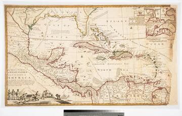
A Map of the West-Indies or the Islands of America in the North Sea
Visual Materials
Kashnor notes, "The map also shows parts of Louisiana and South Carolina, and Central America. It is dedicated to William Paterson, the promoter of the Darien Colony." Kashnor dates as ca. 1720. View of Mexico City. Five submaps. See also 105:328M for another copy. View of Mexico City with building key; Submaps: St. Augustine; Vera Cruz; Havana; Darien; Cartagena.. "with the adjacent Countries; explaning [sic] what belongs to Spain, England, France, Holland &c. also the Trade Winds, and the several Tracts [sic] made by the Galeons [sic] and Flota from place to place. According to the Newest and most Exact Observations by Herman Moll Geographer." "To Wil. Paterson Esq; This map of the West-Indies &c. is most Humbly Dedicated by Herman Moll Geographer." Prime meridian: London. Relief: pictorial. Graphic Scale: Miles, leagues. Projection: Pseudocylindrical. Printing Process: Copper engraving. Other Features: VignettesSub-maps. Verso Text: MS notes: 958.
105:958 M

A New Map of the West Indies; or the Islands of America in the North Sea
Visual Materials
Kashnor notes, :Shows the coast of present-day Texas, and locates the Acansa and Teaucas Land, 'The People about this river are continually in Wars with the Spaniards'." Four harbor submaps. Submaps: A Draught of the Bay & City of Havana; The Bay of Porto Bella; A Draught of the Sity of Cartogena, its Harbour & Forts; La Vara Cruz. Cartouche: Soldiers, battle.. " With the Adjacent Parts, Explaining what belongs to England, Holland, Spain, France, &c. Also the Several Tracts made by the Gallions and Flota. by N. Vischer of Amsterdam. Is now done into English with many Considerable improvements according to the Newest and Best Observations." Prime meridian: Ferro. Relief: pictorial. Graphic Scale: Miles, leagues. Projection: Cylindrical. Printing Process: Copper engraving. Other Features: Sub-mapsCartouche.
105:800 M
The Seat of the War in the West Indies, or the Islands of America in the North Sea
Visual Materials
Kashnor notes, "Issued during the War of the Spanish Succession, and makes a special feature of showing the tracks of the Spanish galleons. Has the declaration of Moll that the map of Mortier is not correct, he has 'vainly assumed the title of Geographer, tho he understands nothing of a map.' " Opening treasure boxes marked w fleur-de-lis. Submaps: Vera Cruz, Cartegena, Havana, Porto Bello.. "Together with the adjacent Dominions; Explaining what belongs to Spain, England, France, Holland, &c. As also the several Tracts made by the Galleons and Flota from place to place, with other considerable Improvements according to the Newest and best Observations. By Robert Morden & Herman Moll." Relief: pictorial. Graphic Scale: Leagues, miles. Projection: Conic. Printing Process: Copper engraving. Other Features: VignettesSub-maps. Verso Text: MS note: D32.
105:971 L
Image not available
The British West Indies : A review of "A narrative of a visit to the West Indies"
Rare Books
76690

West Indies : Bonacca Island / by Lieut. Thomas Smith R.N
Rare Books
Bonacca Island was described by the U.S. Hydrographic Office in 1890 in The navigation of the Gulf of Mexico and Caribbean Sea. Based on that description and satellite photographs from NASA, this island has been identified with Isla de Guanaja. "Soundings in fathoms." "Cay No. IX: 16°16'45" N., 85°52'45" W." "H.W.F. & C. IXth Om. Rise 18 inches." Prime meridian: GM. Relief: hachures. Graphic Scale: Miles. Projection: Plane. Printing Process: Lithography.
493192
Image not available
North America and the West Indies;
Visual Materials
Kashnor notes, "An exceedingly rare map, shoWing the country West of the Mississippi, the boundaries of Virginia, North and South Carolina, reaching to that river. The inset map of the country locates Old Forts EdWard, William Henry, Frederic, St. John, and Chamilles to the St. LaWrence, and Albany, Schenectadi, Forts Hunter and OsWego to Lake Ontario." Kashnor dates as ca. 1764. Submaps and treaty articles. See 093:532 for another copy. "a NeWMap, Wherein the British Empire and its limits, according to the difinitive (sic) Treaty of Peace in 1763, are accurately described, and the Dominions possessed by the Spaniards, the French and other European States; the Whole compiled from the NeWSurveys and Authentic Memoirs that have hitherto appeared. " Cartouche With Natives. Submaps: Particular Map of Baffin and Hudson's Bay; Map of the Country betWeen Montreal, Albany and OsWego. Paper sale tag, June 7, 1927 With MS note: #669.. Prime meridian: London, Ferro. Relief: pictorial. Graphic Scale: Miles, Leagues. Projection: Pseudocylindrical. Printing Process: Copper engraving. Other Features: CartoucheSub-mapsFigures .
105:669 M