Rare Books
Domesday;, or, an actual survey of South-Britain, by the commissioners of William the Conqueror, ... faithfully translated, with an introduction, notes, and illustrations, by Samuel Henshall, ... and John Wilkinson, ... This number comprehends the counties of Kent, Sussex, and Surrey, number one
Image not available
You might also be interested in
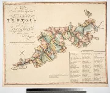
To Isaac Pickering Esqr of Fox Lease Hants this Plan of Tortola From actual Survey by George King is dedicated by His most obedient humble Servant Robt. Wilkinson
Visual Materials
Kashnor notes, "With a list of 104 plantations indicated on plan, with owners names." Pickering held the westernmost point of this island in the British Virgin Islands. Reference table listing owners and parcel numbers. MS note: 843 29. Prime meridian: GM. Relief: hachures. Graphic Scale: Miles, chains. Projection: Plane. Printing Process: Copper engraving. Verso Text: MS note: 843.
093:843 M

Plan of the Island of Tobago, laid down by actual survey under the Direction of the Honorable the Commissioners for the Sale of Lands in the Ceded Island by John Byres Chief Surveyor 1776. I. Bayley Sculp London Republished 14 July 1794, by Robert Wilkinson No. 58 Cornhill
Visual Materials
Shows lands set aside by the Crown for "Poor Settlers." Prime meridian: London, Ferro. Relief: hachures. Graphic Scale: Miles, chains. Projection: Cylindrical. Printing Process: Copper engraving. Verso Text: MS notes: 839 43.
093:839 M

Plan of the Island of Dominica Laid down by Actual Survey under the Direction of the Honorable the Commissioners for the Sale of Lands in the Ceded Island by John Byers Chief Surveyor 1776. J Bayly Sculp London
Visual Materials
Kashnor notes, "Dedicated to Thomas Shirley, Governor of Dominica, William Stuart, Lieutenant Governor, &c. An exceedingly fine map, very fully detailed, showing the lots intended for sale, with their respective numbers." Prime meridian: London. Relief: hachures. Graphic Scale: Miles. Projection: Plane. Watermark: J Whatman . Printing Process: Copper engraving. Verso Text: MS notes: 390 13 14 15.
105:390 M

Plan of the Island of St. Vincent laid down by Actual Survey under the Direction of The Honourable the Commissioners for the Sale of Lands in the Ceded Islands by John Byres Chief Surveyor 1776. J. Bayly Sculp. London
Visual Materials
Prime meridian: Ferro, London. Relief: hachures. Graphic Scale: Miles, chains . Projection: Cylindrical. Watermark: . Printing Process: Copper engraving. Verso Text: MS note: 833.
093:833