Rare Books
A general survey of that part of the island of St. Christophers, : which formerly belonged to France; and was yielded up to Great Britain for ever, ... By Mr. R. M
Image not available
You might also be interested in

The Principall Islands in America belonging to the English Empire viz Jamaica, Barbados, Antegoa, St. Christophers, & Bermudos
Visual Materials
Five maps and two submaps on oner sheet. Kashnor dates as ca. 1690. Submaps: Jamaica; Antegoa; St. Christopher; Barbados; General map of the Cariby Islands; Port Royal; St. Michael or Bridg town. Prime meridian: London. Relief: pictorial. Projection: Plane. Printing Process: Copper engraving. Other Features: Sub-maps. Verso Text: MS note: 970.
105:970 M
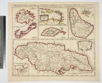
Principall Islands in America Belonging to the English Empire, viz Jamaica, Barbados, Antegoa, St. Christophers, & Bermudos
Visual Materials
Kashnor notes, "Contains one of the rarest maps of Bermuda." Kashnor dates as ca. 1685. Eight maps on one sheet. See 105:190 for later revised version. Eight maps on one sheet.. Relief: pictorial. Projection: Plane. Watermark: H. Printing Process: Copper engraving. Other Features: Sub-maps. Verso Text: MS note: 192.
105:192 M
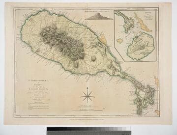
St. Christophers, or St. Kitts, surveyed By Anthony Ravell Esqr. Surveyor General of the Islands of St. Christophers, Nevis, & Montserrat. Engraved by Thomas Jefferys Geographer to the King
Visual Materials
See 093:828M for a later copy. Vignette: Nevis from shipboard Submap: Nevis, by Thomas Jefferys.. Prime meridian: London, Ferro. Relief: hachures. Graphic Scale: Miles, leagues. Projection: Cylindrical. Watermark: Crowned fluer-di-lid TW. Printing Process: Copper engraving. Other Features: VignettesSub-maps. Verso Text: MS notes: 827 43.
093:827 M

St. Christophers, or St. Kitts, surveyed By Anthony Ravell Esqr. Surveyor General of the Islands of St. Christophers, Nevis, & Montserrat. Engraved by Thomas Jefferys Geographer to the King
Visual Materials
See 093:827M for an earlier copy. Vignette: Nevis from shipboard Submap: Nevis, by Thomas Jefferys.. Prime meridian: London, Ferro. Relief: hachures. Graphic Scale: Miles, leagues. Projection: Cylindrical. Printing Process: Copper engraving. Other Features: VignettesSub-maps. Verso Text: MS notes: 828.
093:828 M

New Map of the Island of St. Christophers being an Actual Survey taken by Mr. Andrew Norwood, Surveyr. Genll. ; New Map of the Island of Guardalupa. ; New Map of the Island of Martineca
Visual Materials
A later copy of Thornton's map. Three maps on one sheet. Kashnor dates as ca. 1730. Relief: pictorial. Graphic Scale: Miles. Projection: Plane. Printing Process: Copper engraving. Verso Text: MS notes: 780.
105:780
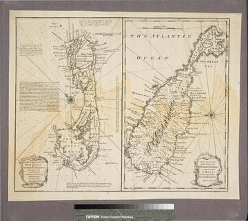
New & Accurate Map of Bermudas or Sommer's Islands, taken from an Actual Survey wherein the Errors of former Charts are corrected. Accurate map of the Island of St. Christopher, vulgarly called St. Kits, Containg all the Towns, Villages, Forts &c
Visual Materials
Two maps on one sheet. Kashnor dates as ca. 1730. RLIN record dates as 1752. Prime meridian: London. Relief: pictorial. Projection: Plane. Printing Process: Copper engraving. Verso Text: MS note: 190.
105:190 S