Rare Books
Map of the Mining Region of California. 1854

You might also be interested in

California Mining Illustrated. Dry Diggings, Wet Diggings & Quartz Mill
Rare Books
Image of dry diggings on a hill to the left, wet diggings on a river to the right, and a smaller vignette of a quartz mill in the lower center. The left and right vignettes are labeled with letters and numbers which correspond to descriptions of mining processes explained in the printed text in the center of the sheet. "Barber & Baker, Publishers, cor. J & 3d sts., Sacramento."--text below title of image. "Entered according to Act of Congress, A.D. 1855, by Barber & Baker, in the Clerk's office of the District Court, for the Northern District of California."--text, below image. Paper color: buff.
48052:002

Map of the Mining Region of California. 1855
Rare Books
Image is of a map of Northern California from Oregon border to Monterey and Mariposa counties. At the lower left are distance from Sacramento. At the upper right are the distances from Stockton, from S. Francisco, from Downeville, and from other locations. "Lithogd. & publd. by Britton & Rey San Francisco."--text, below image. Paper color: blue.
48052:027

The California Indians
Rare Books
Image contains eight vignettes depicting California Native Americans engaged in various activities and customs. The text in the center of the image describes each vignette. "Anthony & Baker SC."text, bottom of every vignette. "C. Nahl del."--text, bottom lower right and lower center vignettes. "Sun Print. Entered according to Act of Congress, in the year 1854, by James M. Hutchings, in the Clerk's Office of the U.S. District Court for the Northern District of California. Orders, pre paid, addressed "Box H, Placerville, El Dorado Co., Cal.""--text, below image. Paper color: blue.
48052:103

Plan of the Burnt District, Sacramento, Showing the Buildings which escaped
Rare Books
Image is of a map from the levee to 7th St. (left to right) and from I St. to L St. (top to bottom). The Sacramento River is labeled at the far left, and Sutter Lake is labeled at the top. The blacked out portion of the map indicates where the fire occurred. Baird notes that this map is said to refer to the fire of July 13th, 1854. "Published by barber & Baker."--text, below image. "Noisy Carriers, San Francisco."--stamped text, upper right corner of image. Paper color: gray.
48052:088

San Francisco Past and Present
Rare Books
Upper image is of the view of Yerba Buena harbor from the south with the town at the left. There is heavy vegetation in the foreground, and several ships can be seen in the harbor. To the right of this illustration is a map of the "Vicinity of San Francisco." Below the image is text providing a brief general history of San Francisco, and some facts and statistics about its growth. "Taken from Rincon Point, by G. H. Baker, June 1, 1849."--text, below upper image. Lower image is a panoramic view of the city with the harbor at the right and the hills beyond. People and animals can be seen in the street at the left. The text providing a brief general history of San Francisco, and some facts and statistics about its growth continues below this image. "Taken from Rincon Point, by G. H. Baker, Dec. 1854."--text, below image. "Entered according to Act of Congress, in the year 1854, by Baber & Baker, in the Clerk's Office of the U. S. District Court. Published by Barber & Baker, Sacramento. M. Ullman, Agent, San Francisco. Printed at the Sun Office."--text, bottom of page. Paper color: blue.
48052:144
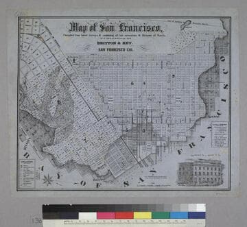
Map of San Francisco
Rare Books
Image is of a map of the downtown area with a vignette of Parrott Block in the lower right corner. The map covers the area from waterfront to Webster, and from North Point to Addition of Mission. At the lower left are nine letter identifications of public buildings on the map and symbols for other locations. At the right are twelve letter identifications for places of worship. "Published by Britton & Rey, San Francisco Cal."--text, below title of map. "Page Bacon & Co. Adams & Co."--text, above vignette in lower right corner. Paper color: blue.
48052:138