Manuscripts
Map of 92 acres sold by the Duke of Buckingham and Chandos to the government for the Newcastle Garrison

You might also be interested in
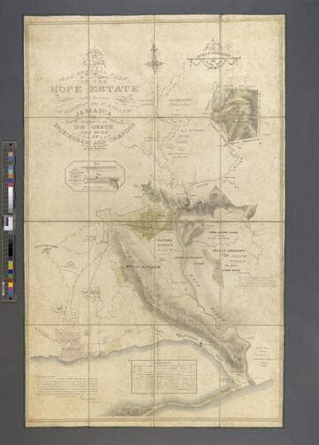
A Plan of the Hope Estate in the Parish of St. Andrew, Jamaica, the Property of His Grace The Duke of Buckingham and Chandos. / Surveyed in the Year 1826 by Edwd. McGeachy
Manuscripts
A detailed map of Hope Estate in 1826 with field plan, location of buildings, homes, and other land uses. Crops grown are enumerated in two reference charts. Scale is 10 chains to one inch.
mssST West Indies Box 11 [map 1826b]
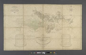
A New and General Plan of the Hope Estate in the Parishes of Kingston and St. Andrew, Jamaica, the Property of His Grace The Duke of Buckingham and Chandos. / Surveyed in the Year 1826 by Edwd. McGeachy
Manuscripts
Hope Estate in 1826 with outline of fields, other plantations, including Papine, Mona, and Hall's Delight, the City of Kingston, and "Merrymans Hill in Coffee". There is also a inset with two illustrations of the division of water to various estates. Scale is 20 chains to one inch.
mssST West Indies Box 11 [map 1826a]
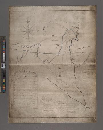
A Plan of Hope Plantation in the Parish of St. Andrew, is also the several parcels of land adjoining thereunto, purchased by Roger Hope Elletson, Esquire, now in possession of His Grace The Duke of Chandos. / Performed by desire of Edwards East, Esquire, in May 1782 per Smellie & Sheriff
Manuscripts
Hope Estate in 1782 with outline of lands, and other plantations, including Little Hope, Papine, and Mona. The map outlines purchases of lands adjacent to the original Hope Plantation purchased by Elletson. Scale is 20 chains to one inch.
mssST West Indies Box 11 [map 1782]
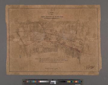
Plan at North Boundary of Black Town
Manuscripts
A map showing the proposed plan for a sewer line and drainage. Scale is 6 inches to a mile.
mssST West Indies Box 11 [map 1849]
Image not available
Map of the Ontario Colony Land / surveyed and mapped by J.C. Dunlap, U.S. Deputy Surveyor
Visual Materials
Old shelf number: eph J4-12(1a,b,c). Three copies of the same map done of three different color paper stock; white, pink, blue. This area is now part of Upland. MS notes on land ownership, etc. Prime meridian: GM. Relief: pictorial. Graphic Scale: Chains. Projection: Plane. Printing Process: Lithography. Verso Text: MS notes and stamp for John S. Collins on (1c) copy.
ephMPCALIFT0081
Image not available
Map of Orange County California / compiled by S.H. Finley 1889. [northwestern section]
Visual Materials
Title and publisher transcription taken from another section of the map; see RB ephMPCALIF0018a for title and southwestern section of map. Old shelf number: eph J4-10(13a). A large map in several sheets. One copy of the southwestern section and two copies of the northwestern section but none of the eastern section of the county. Many property owners identified. MS notes: 0-7. S2/4. Santa Ana & Surr'd'g Country. Prime meridian: GM. Relief: hachures. Graphic Scale: Chains. Projection: Cylindrical. Printing Process: Lithography. Verso Text: Ms notes: Eph J4-10 (13a&b) W. H. Holabird Douglas Building Los Angeles Cal. Stamp; Wells Fargo Express from Santa Ana Cal. noted as "from S. H. Finley." C-11.
ephMPCALIF0018b