Manuscripts
Plan at North Boundary of Black Town

You might also be interested in
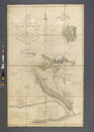
A Plan of the Hope Estate in the Parish of St. Andrew, Jamaica, the Property of His Grace The Duke of Buckingham and Chandos. / Surveyed in the Year 1826 by Edwd. McGeachy
Manuscripts
A detailed map of Hope Estate in 1826 with field plan, location of buildings, homes, and other land uses. Crops grown are enumerated in two reference charts. Scale is 10 chains to one inch.
mssST West Indies Box 11 [map 1826b]

Map of 92 acres sold by the Duke of Buckingham and Chandos to the government for the Newcastle Garrison
Manuscripts
Two copies of the same map showing the land sold. Scale is 10 chains to one inch.
mssST West Indies Box 11 [map 1842]
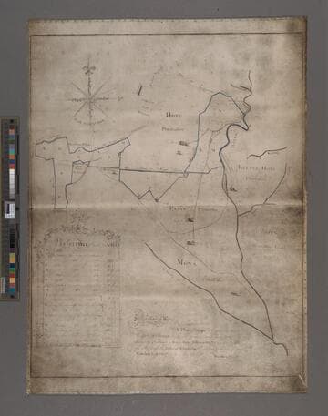
A Plan of Hope Plantation in the Parish of St. Andrew, is also the several parcels of land adjoining thereunto, purchased by Roger Hope Elletson, Esquire, now in possession of His Grace The Duke of Chandos. / Performed by desire of Edwards East, Esquire, in May 1782 per Smellie & Sheriff
Manuscripts
Hope Estate in 1782 with outline of lands, and other plantations, including Little Hope, Papine, and Mona. The map outlines purchases of lands adjacent to the original Hope Plantation purchased by Elletson. Scale is 20 chains to one inch.
mssST West Indies Box 11 [map 1782]
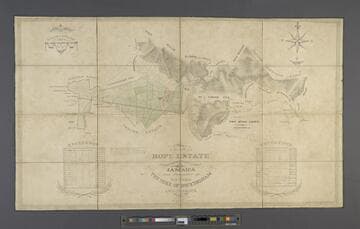
A New and General Plan of the Hope Estate in the Parishes of Kingston and St. Andrew, Jamaica, the Property of His Grace The Duke of Buckingham and Chandos. / Surveyed in the Year 1826 by Edwd. McGeachy
Manuscripts
Hope Estate in 1826 with outline of fields, other plantations, including Papine, Mona, and Hall's Delight, the City of Kingston, and "Merrymans Hill in Coffee". There is also a inset with two illustrations of the division of water to various estates. Scale is 20 chains to one inch.
mssST West Indies Box 11 [map 1826a]