Manuscripts
Account of the encounter between the French and English fleets off the islands of St. Christopher and Nevis, West Indies, January 1782

You might also be interested in

West India Islands - St. Christophers. ; West India Islands - Nevis. ; West India Islands - St. Lucia
Visual Materials
Three maps on one sheet. Kashnor dates as [1816]. Prime meridian: London, Ferro. Relief: hachures. Graphic Scale: Miles, leagues. Projection: Plane. Printing Process: Copper engraving. Verso Text: MS notes: 777 West Indies Thomson.
105:777
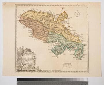
Martinico, one of the Caribbee Islands, in the West Indies; Subject to the French. according to Observations of Mr. Houel Engineer, by Thos. Jefferys, Geographer ti His Royal Highness the Prince
Visual Materials
Kashnor dates ca. 1760. Cartouche: framed with sugar cane. MS note: 813. Prime meridian: Ferro, London. Relief: hachures. Graphic Scale: Miles, leagues. Projection: Cylindrical. Watermark: Crowned fluer-di-lis over IVC. Printing Process: Copper engraving. Other Features: Cartouche. Verso Text: M
093:813 S
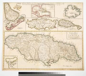
Map of the English Empire in the Ocean of America or West Indies, revised by J. Senex; A New Map of the Island of Jamaica; Barbados & Bermuda; Tobago; Antego; St. Christophers; Harbour at Port Royall
Visual Materials
Kashnor notes," The map of Bermuda locates all the tribes." This map is eight maps on one sheet. See 105:192 for earlier version of this map. Eight maps on one sheet. MS notes: 10 Sen 0 Savanna, signifies a Plain . Relief: pictorial. Graphic Scale: varies. Projection: Plane. Printing Process: Copper engraving. Other Features: Sub-maps. Verso Text: MS note: 191.
105:191 M