Visual Materials
World (The), including the late Discoveries, by Capt. Cook and other Circumnavigators
You might also be interested in
Image not available
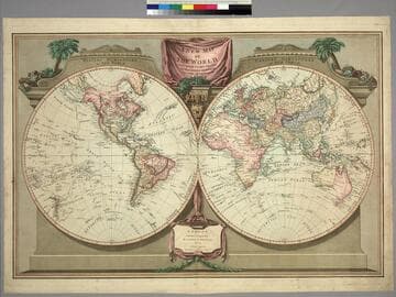
New Map of the World, with Captain Cook's Tracks, his Discoveries and those of the other Circumnavigators
Visual Materials
Kashnor notes, "Probably the last map issued before the discoveries of Vancouver and La Perouse. Locates New Albion, Drake's Harbor, Port Monterey, Dixon's Strait, Nootka and Fuca Entrance." See 105:271M for a later version (1812). Prime meridian: Ferro. Relief: no. Graphic Scale: No. Projection: Dual Hemisphere. Printing Process: Copper engraving. Verso Text: MS note: 48.
105:048 M
New Map of the World, with Captain Cook's Tracks, his Discoveries and those of the other Circumnavigators
Visual Materials
Kashnor notes, "Locates San Francisco, P. Sir Francis Drake, Port Diego, and Monterey Bay; also the Oregon River." See 105:048 for an earlier version (1794). Vancouver Island now appears and Tasmania is separated. Prime meridian: Ferro. Relief: no. Graphic Scale: No. Projection: Dual Hemisphere. Printing Process: Copper engraving. Verso Text: MS note: 271.
105:271 M
Image not available
New Map of the World, with Captain Cook's Traacks, His Discoveries and Those of the Other Circumnavigators
Visual Materials
Kashnor notes, "Shows all the west coast and locates the Oregon River,Vancouver's discoveries, and it is one of the earliest English maps to locate Great Salt Lake under the name of Nadonessis." Decorative surround.. Prime meridian: Ferro. Relief: pictorial. Projection: Dual Hemisphere. Printing Process: Copper engraving. Verso Text: MS note: 560.
093:560 M
Image not available
The World with the Latest Discoveries. Drawn & Engraved by James Wallis
Visual Materials
Kashnor notes, "Locates Drake's Bay and New Albion, Nootka Sound and Port Banks." Prime meridian: Ferro. Relief: pictorial. Projection: Dual Hemisphere. Printing Process: Copper engraving. Verso Text: MS note: 303.
105:303 S
Image not available
Map of the World
Visual Materials
Kashnor notes, "Shows a good coastline to the North-West and Alaska, locating New Albion, Nootka Sound, River of the West, and shows Cook's track to Icy Cape." Prime meridian: Ferro. Relief: pictorial. Graphic Scale: No. Projection: Dual Hemisphere. Printing Process: Copper engraving.
105:034 M
Image not available
A new and correct map of the World : laid down according to the newest observations & discoveries in several different Projections : including the trade winds monsoons variation of the compass and illustrated with a Coelestrial Planisphere, the various systems of Ptolemy, Copernicus, and Tycho Brahe. Together with the appearances of the planets &c
Visual Materials
Having five different projections showing California as an Island. ;Sold by George Wildey at ye Great Toy and Print Shop, ye corner of Ludgate Street next St. Pauls Church Yard London. ; Submaps: Seven different projections of earth, two celestial, numerous heavenly body representations.. Prime meridian: London. Relief: pictorial. Projection: Dual Hemisphere. Printing Process: Copper engraving. Other Features: Sub-maps.
105:255