Visual Materials
New Map of the World, with Captain Cook's Tracks, his Discoveries and those of the other Circumnavigators
You might also be interested in
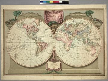
New Map of the World, with Captain Cook's Tracks, his Discoveries and those of the other Circumnavigators
Visual Materials
Kashnor notes, "Locates San Francisco, P. Sir Francis Drake, Port Diego, and Monterey Bay; also the Oregon River." See 105:048 for an earlier version (1794). Vancouver Island now appears and Tasmania is separated. Prime meridian: Ferro. Relief: no. Graphic Scale: No. Projection: Dual Hemisphere. Printing Process: Copper engraving. Verso Text: MS note: 271.
105:271 M
Image not available
New Map of the World, with Captain Cook's Traacks, His Discoveries and Those of the Other Circumnavigators
Visual Materials
Kashnor notes, "Shows all the west coast and locates the Oregon River,Vancouver's discoveries, and it is one of the earliest English maps to locate Great Salt Lake under the name of Nadonessis." Decorative surround.. Prime meridian: Ferro. Relief: pictorial. Projection: Dual Hemisphere. Printing Process: Copper engraving. Verso Text: MS note: 560.
093:560 M
Image not available
The World with the Latest Discoveries. Drawn & Engraved by James Wallis
Visual Materials
Kashnor notes, "Locates Drake's Bay and New Albion, Nootka Sound and Port Banks." Prime meridian: Ferro. Relief: pictorial. Projection: Dual Hemisphere. Printing Process: Copper engraving. Verso Text: MS note: 303.
105:303 S
Image not available
Chart exhibiting the New Discoveries in the North & South Pacific Ocean, also those on the North-west Coast of America
Visual Materials
Kashnor notes, "Shows a good coastline to the North-West, and locates Port Sir Fran. Drake, Juan de Fuca Strait, Nootka Sound and other discoveries by Cook." Kashnor notes date as ca. 1780. Prime meridian: GM. Relief: no. Graphic Scale: No. Projection: Mercator. Printing Process: Copper engraving.
105:014 M
Image not available
Map of the World
Visual Materials
Kashnor notes, "Shows a good coastline to the North-West and Alaska, locating New Albion, Nootka Sound, River of the West, and shows Cook's track to Icy Cape." Prime meridian: Ferro. Relief: pictorial. Graphic Scale: No. Projection: Dual Hemisphere. Printing Process: Copper engraving.
105:034 M
Image not available
A New Chart of the World on Wright's or Mercator's Projection in which are Exhibited All the Parts Hitherto Explored or Discovered with the Tracks of the British Circumnavigators Byron, Wallis, Carteret and Cook, &c. and the track of la Pérouse in the Pacific Ocean
Visual Materials
Kashnor notes, "A valuable map of the North-West Coast, showing the discoveries and tracks of La Perouse and Vancouver, 1793-95. It locates Drake's Harbour and Monterey in California, and the Columbia River is still called the Oregon." See 105:043 and 105:261 for this map as issued in 1794, 093:044 and 105:262 for an 1800 version. Minimum cartouche with compass rose on top. Published information moved to make room for reference to la Pérouse.. Prime meridian: London. Relief: pictorial. Graphic Scale: No. Projection: Mercator. Printing Process: Copper engraving. Other Features: Cartouche. Verso Text: MS note: 263 3.
105:263 M