Visual Materials
The World with the Latest Discoveries. Drawn & Engraved by James Wallis
You might also be interested in
Image not available
New Map of the World, with Captain Cook's Tracks, his Discoveries and those of the other Circumnavigators
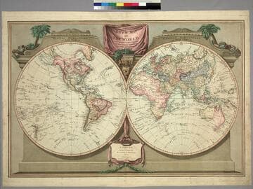
Visual Materials
Kashnor notes, "Probably the last map issued before the discoveries of Vancouver and La Perouse. Locates New Albion, Drake's Harbor, Port Monterey, Dixon's Strait, Nootka and Fuca Entrance." See 105:271M for a later version (1812). Prime meridian: Ferro. Relief: no. Graphic Scale: No. Projection: Dual Hemisphere. Printing Process: Copper engraving. Verso Text: MS note: 48.
105:048 M
Image not available
Map of the World
Visual Materials
Kashnor notes, "Shows a good coastline to the North-West and Alaska, locating New Albion, Nootka Sound, River of the West, and shows Cook's track to Icy Cape." Prime meridian: Ferro. Relief: pictorial. Graphic Scale: No. Projection: Dual Hemisphere. Printing Process: Copper engraving.
105:034 M
New Map of the World, with Captain Cook's Tracks, his Discoveries and those of the other Circumnavigators
Visual Materials
Kashnor notes, "Locates San Francisco, P. Sir Francis Drake, Port Diego, and Monterey Bay; also the Oregon River." See 105:048 for an earlier version (1794). Vancouver Island now appears and Tasmania is separated. Prime meridian: Ferro. Relief: no. Graphic Scale: No. Projection: Dual Hemisphere. Printing Process: Copper engraving. Verso Text: MS note: 271.
105:271 M
Image not available
New and Correct Map of the World, laid down according to the newest discoveries and from the most exact observations by Herman Moll, Geographer
Visual Materials
Kashnor notes, "Shows the North-West coast as far as the supposed Strait of Anian, and locates New Albion and the Port Sir Francis Drake. The Longue River of La Hontan appears to follow the course of the Upper Missouri." Moll carefully points out mistakes made by Sanson by showing phantom coastlines and skewers Dutch mapmakers for copying maps without attribution. See 093:185 and 093:186 for later copies. Cartouche- mermen with flags. Submaps compare Ptolemaic system with Copernican, views of moon, sun and planets. Depiction of trade winds.. Prime meridian: Ferro. Relief: pictorial. Projection: Dual Hemisphere. Printing Process: Copper engraving. Other Features: Sub-mapsCartouche. Verso Text: MS note: 258/105.
105:258 M
Image not available
North America
Visual Materials
Kashnor notes, "A scarce map, locating Sir F. Drake's Harbour, New Albion, Monterey, San Diego, Nootka Sound, &c." Insert map of Caribbee Isles. MS note: 279 (on backing). Submap of Caribbee Isles.. Prime meridian: London. Relief: pictorial. Projection: Conic. Printing Process: Engraving. Other Features: Sub-maps.
105:279 S
Image not available
Northern Hemisphere; Southern Hemisphere
Visual Materials
Kashnor notes, "The Northern Hemisphere shows the knowledge of the North-West to date, giving locations to Nootka Sound, De Fuca's Entrance, Port Banks, K. William Sound, Cook's River, etc." Prime meridian: GM. Relief: pictorial. Graphic Scale: No. Projection: Polar, dual hemisphere. Printing Process: Copper engraving. Verso Text: MS. note: 40..
093:040 M