Visual Materials
Mappe-Monde pour connoitre les progrés & les conquestes les plus Remarquables des Province-Unies, Ainsy que celles des Compagnies d'Orient et d'Occident, et les Pais qu'elles possédent dans l'autre Hemisphere
You might also be interested in
Image not available
Mappe-Monde=Geo-Hydrographique, ou Description Generale du Globe Terrestre et Aquatique en Deux Plans-Hemispheres, ou sont exactement en General Toutes les Parties de la Terre et de l'Eau, suivant les relations les plus Nouvelles. Par le Sr. Sanson Geographe ordinaire du Roy
Visual Materials
Kashnor notes, "Shows California as an island, and inserts 'Terre de Jesso ou Je co' between 40 deg. and 50 deg." This map was originally drawn from Sanson's model in 1674. Since this copy is undated, Shirley suggest it is State 3 of Plate IV, done after 1696. Cordier sc. missing this state. Elaborate cartouche of putti on dolphins, mermen below.. Prime meridian: Ferro. Relief: pictorial. Projection: Dual Hemisphere. Printing Process: Copper engraving. Other Features: Cartouche. References: Shirley 462; BL 150.e13; Wagner 409a.. Verso Text: MS note: 246.
105:246 M
Image not available
L'Amerique Meridionale, divisée en ses Principales Parties, Scavoir La Terre Ferme, Le Perou, Le Chili, Le Bresil, Le Paraguay, La Terre et Les Isles Magellaniques, ou sont Distingués, Les uns des autres, Le Estats comme ils sont Presentement Possedés par les Francois, Castillans, Portugais, Hollandois, &c
Visual Materials
This is a later imprint of map 105:834M. Note redone lettering in several places. Cartouche: Natives & parrots, (2) natives and animals.. "Dressée sur toutes les Relations qui ont par jusques apresent. Par le Sr. Sanson. Geographe Oridnaire du Roy. 1696." Prime meridian: Ferro. Relief: pictorial. Graphic Scale: Miles, leagues. Projection: Pseudocylindrical. Printing Process: Copper engraving. Other Features: Cartouche. Verso Text: MS note: 835.
105:835 M
Image not available
Mappe-Monde Dresée sur les Observations de Mrs. de l'Academie Royale des Sciences et quelques autres et sur les memoires les plus recens. A son Altesse Royale Monseigneur le Duc de Chartes
Visual Materials
Kashnor notes, "Shows the Gulf of California only reaching as high as the Bona Guia, but without the definite termination; also shows New Holland and part of New Zealand, with the tracks of Mendana, Dampier, Olivier, Tasman, Pelsart, Magellan and le Maire." This appears to be a later state of the 1700 map, see 093:180. The slant of South America has been corrected eastward, some new names appear on the west coast of Africa, and a new mountain range in Siberia. Image is lighter than 1700 original. See also 093:181, 105:244 and 105:245 for later editions. Cartouche - figures representing four continents. Prime meridian: Ferro. Relief: pictorial. Projection: Dual Hemisphere. Watermark: Chained Maltese cross. Printing Process: Copper engraving. Other Features: Cartouche. References: Shirley 603. Verso Text: MS notes: 245.
105:245 M
Image not available
Carte du Canada ou de la Nouvelle France et des Decouvertes qui y ont été faites Dresée sur les Observations les plus Nouvelles, & sur divers Mémoires tant Manuscrits qu' imprimez
Visual Materials
Kashnor notes, "This is the Châtelain map, taken from DeLisle. It locates only the French forts around Hudson's Bay, and shows a correct idea of the locations of the Indian tribes west of the Great Lakes; also shows La Houton's assumed location of the great River of the West, and the western sea beyond the range of mountains." Kashnor dates as ca. 1720. See 105:431 for another version, 105:433 for an earlier version. Historical remarks replace of cartouche on 105:431 version.. Prime meridian: Ferro?. Relief: pictorial. Graphic Scale: Miles, leagues. Projection: Pseudocylindrical. Printing Process: Copper engraving. Verso Text: MS note: 432.
105:432 M
Image not available
Mappe-Monde Dresée a l'usage du Roy. Par Guillaume Delisle Premier Geographe de S. M
Visual Materials
Kashnor notes, "The western coast of America goes no further north than Cape Blanc, but California is a peninsula, although the gulf is very incorrectly represented. New Guinea appears as part of Australia. The route of Tasmon's voyage in 1642 is shown. This is one of Delisle's earlier maps, which show California as a peninsula." This is a copy of L'Isle's 1700 map (093:180) with added border art, redone cartouche, the tip of South America corrected, the Solomon Islands moved. Compare with 093:181M which Kashnor dated as [1720]. This map has a more correctly drawn California peninsula. Frisland is no longer shown below Greenland on this map. RLIN record gives appeared in information. Cartouche - figures representing four continents. Royal crest center. . Prime meridian: Ferro. Relief: pictorial. Projection: Dual Hemisphere. Printing Process: Copper engraving. Other Features: CartoucheSub-maps. References: Shirley 603 (mentioned). Verso Text: MS notes: 181.
105:244 M
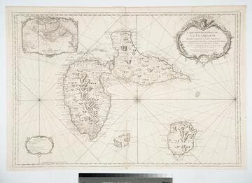
Carte Reduite des Isles de la Guadaloupe Marie Galante et les Saintes Dresée au Depost des Cartes Plans et Journaux de la Marine Pour le Service des Vaisseaux du Roy Par Ordre de M. Berryer Ministre et Secretaire d Etat aiant le Departement de la Marine. Par le Sr. Bellin Ingeneur de la Marine et du Depost des Plans Confuer Royal de l'Academie de Marine et de la Societe Royale de Londres. MDCCLIX (1759)
Visual Materials
Sub-map of Fort Louis. Cartouche: Royal crown and florals. Sub-map: Environs du Fort Louis.. Prime meridian: Paris. Relief: pictorial & hachures. Graphic Scale: Leagues. Projection: Plane. Watermark: Winged figure lettering. Printing Process: Copper engraving. Other Features: CartoucheSub-maps. Verso Text: MS note: 405.
105:405 M