Visual Materials
A map of the colony of Rhode Island : with the adjacent parts of Connecticut, Massachusets [sic] Bay, &c. / by Thos. Kitchin Senr. Hydrographer to his Majesty

You might also be interested in

Seat of the war in the environs of Philadelphia / by Thos. Kitchin Senr. Hydrographer to his Majesty
Visual Materials
Kashnor dates as 1777. RLIN notes "For the London Magazine, 1777." MS note: 138 (on backing). Prime meridian: London. Relief: pictorial. Graphic Scale: Miles. Projection: Cylindrical. Printing Process: Copper engraving.
105:138 S
Image not available
Map of New England and Nova Scotia; with part of New York, Canada, and New Britain & the adjacent Islands of New Found Land Cape Breton &c. by Tho. Kitchin Geogr
Visual Materials
Kashnor notes, "A scarce map issued at the time of the Old French War." RLIN record gives date and published in information. Cartouche: harbor/forest scene. MS note: 280 (on backing). Prime meridian: London. Relief: pictorial. Graphic Scale: Miles. Projection: Cylindrical. Watermark: Seal circular device. Printing Process: Copper engraving. Other Features: Cartouche. References: Kershaw 708; McCorkle 758.7. Verso Text: MS note: 280 (on backing).
093:280 S

Accurate Map of Rhode Island, Part of Connecticut and Massachusets (sic), Showing Admiral Arbuthnot's Station in Blocking up Admiral Ternay
Visual Materials
Longitude from London shown incorrectly. Stamped "Owens College Library, Manchester" MS note :141 (on backing). Prime meridian: London. Relief: pictorial. Projection: Mercator. Printing Process: Copper engraving.
105:141 S
Image not available
A map of the colonies of Connecticut and Rhode Island : divided into counties and townships / from the best authorities, by Tho Kitchin Geogr
Rare Books
Appeared in April 1758 edition of London Magazine. Cartouche: Shrubery MS note Maps 31. Prime meridian: London. Relief: pictorial. Graphic Scale: Miles. Projection: Cylindrical. Printing Process: Copper engraving. Other Features: Cartouche. Verso Text: MS note: 150249.
150249

West Indies
Visual Materials
Kashnor notes, "Engraving representing sugar being embarked." Kashnor dates as [1760]. Cartouche: Traders & slave MS note: 976 (on backing).. Prime meridian: London. Relief: pictorial. Graphic Scale: Miles. Projection: Conic. Printing Process: Copper engraving. Other Features: Cartouche.
105:976 S
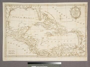
Map of the Gulf of Mexico, the Islands and Countries adjacent
Visual Materials
"For the Rev. Dr. Robertson's History of America. By Thos. Kitchin Senr. Hydrographer to his Majesty." "Vol. I (upper right)" Cartouche: leafy boughs.. Prime meridian: Ferro. Relief: pictorial. Graphic Scale: Miles, leagues. Projection: Polar. Printing Process: Copper engraving. Other Features: Cartouche. Verso Text: MS note: 955.
105:955 S