Visual Materials
Accurate Map of Rhode Island, Part of Connecticut and Massachusets (sic), Showing Admiral Arbuthnot's Station in Blocking up Admiral Ternay

You might also be interested in

New and accurate Map of Connecticut and Rhode Island from the best Authorities
Visual Materials
Kashnor shows date as c.1775. [Longitude incorrectly shown.] MS note: 88 (on backing). Prime meridian: London. Relief: pictorial. Projection: Mercator. Watermark: Crowned seal of Britannia S&K. Printing Process: Copper engraving.
105:088

Accurate Map of Rhode Island, Part of Connecticut and Massachusets (sic), shewing Admiral Arbuthnot's Station in Blocking up Admiral Ternay
Visual Materials
Kashnor notes, "A scarce map locating the old roads." Ms note: 124 (on backing). Prime meridian: London. Relief: pictorial & hachures. Projection: Cylindrical. Printing Process: Copper engraving. Verso Text: Ms note: 124 (on backing).
093:124 S
![A map of the colony of Rhode Island : with the adjacent parts of Connecticut, Massachusets [sic] Bay, &c. / by Thos. Kitchin Senr. Hydrographer to his Majesty](/_next/image?url=https%3A%2F%2Frail.huntington.org%2FIIIF3%2FImage%2F22APN4KVVFFN%2Ffull%2F%5E360%2C%2F0%2Fdefault.jpg&w=750&q=75)
A map of the colony of Rhode Island : with the adjacent parts of Connecticut, Massachusets [sic] Bay, &c. / by Thos. Kitchin Senr. Hydrographer to his Majesty
Visual Materials
Kashnor notes, "A scarce map, issued during the Revolution." MS note :142 (on backing). Prime meridian: London. Relief: no. Graphic Scale: Miles, Leagues. Projection: Mercator. Printing Process: Copper engraving. Other Features: Cartouche.
105:142 S
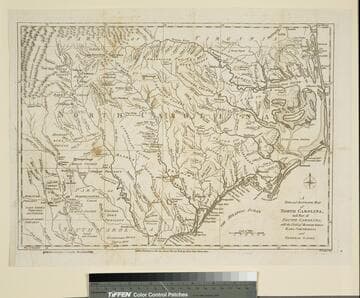
New and Accurate Map of North Carolina, and Part of South Carolina, with the Field of Battle between Earl Cornwallis and General Gates
Visual Materials
Duplicate of 093:074S. This copy stamped "Owens College Library, Manchester." Prime meridian: London. Relief: pictorial. Graphic Scale: Miles. Projection: Cylindrical. Watermark: Crowned oval. Printing Process: Copper engraving. Verso Text: MS note: 76 (on backing).
105:076 S

A map of Connecticut and Rhode Island, with Long Island Sound, &c
Visual Materials
Kashnor notes, "An interesting old map, published during the American Revolution, showing the old roads and towns." Kashnor dates c.1776. RLIN record notes publication in Gentleman's Magazine, November, 1776, vol. 46. Notes copper mines shown near Simsbury, CT. Place of publication assumed: Gentleman's Magazine is a London publication. MS note: 90 (on backing). Prime meridian: London. Relief: pictorial. Graphic Scale: Miles. Projection: Plane. Printing Process: Copper engraving. Verso Text: MS note: 90 (on backing).
093:090 S

New and Accurate Map of the Province of New York and Part of Jerseys, New England and Canada, Showing the Scenes of our Military Operations during the present War. Also the New Erected State of Vermont
Visual Materials
Appeared in information from McCorkle. MS note: 125 (on backing). Prime meridian: London. Relief: pictorial. Projection: Mercator. Watermark: Seal. Printing Process: Copper engraving. References: McCorkle 780.9.
105:125 S