Visual Materials
New and accurate Map of Connecticut and Rhode Island from the best Authorities

You might also be interested in

Accurate Map of Rhode Island, Part of Connecticut and Massachusets (sic), Showing Admiral Arbuthnot's Station in Blocking up Admiral Ternay
Visual Materials
Longitude from London shown incorrectly. Stamped "Owens College Library, Manchester" MS note :141 (on backing). Prime meridian: London. Relief: pictorial. Projection: Mercator. Printing Process: Copper engraving.
105:141 S

A new and accurate map of New Jersey, from the best authorities
Visual Materials
RLIN reference gives author, place of production, and notes this map is from Universal Magazine, v. 66, June 1780. Kashnor dates as circa 1780. MS note: 113 (on backing). Prime meridian: London. Relief: pictorial. Projection: Mercator. Watermark: Seal. Printing Process: Copper engraving.
105:113 S
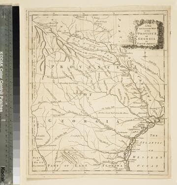
A new and accurate map of the province of Georgia in North America
Visual Materials
Kashnor notes," An old map published about 1775, shewing the roads and Indian paths." Kashnor dates c.1775. Duplicate map to 093:094S, 093:391. RLIN record notes date as [1779?] and place of publication as [London?] and as appearing in The Universal Magazine of 1779. MS note: 103 (on backing). Prime meridian: [Ferro]. Relief: pictorial. Projection: Cylindrical. Watermark: Crowned circular seal. Printing Process: Copper engraving.
105:103 S

An accurate map of New Hampshire in New England, from a late survey
Visual Materials
Kashnor dates as ca. 1776. Maine is shown as part of New Hampshire. RLIN record gives place of publication, date, and appeared in information as Universal magazine of knowledge and pleasure, March, 1781. MS note: 112 (on backing). Prime meridian: London. Relief: pictorial. Projection: Cylindrical. Watermark: Seal. Printing Process: Copper engraving. References: McCorkle N781.1.
105:112 S

New and Accurate Map of the Chief Parts of South Carolina, and Georgia, From the Best Authorities
Visual Materials
Kashnor notes, "Published during the Revolution, this map shows the main roads in both provinces." See 093:076S for another copy. District and Township lines marked. MS note: 75 (on backing). Prime meridian: London. Relief: no. Graphic Scale: Miles. Projection: Cylindrical. Watermark: Crowned circle with lion clutching arrows. Printing Process: Copper engraving. Verso Text: MS note: 75 (on backing).
093:075 S

Map of the Country round Philadelphia including part of New Jersey New York Staten Island & Long Island
Visual Materials
Kashnor notes, "a scarce war map." MS note: 121 (on backing). Prime meridian: London. Relief: pictorial. Graphic Scale: Miles, British Statute. Projection: Cylindrical. Watermark: Crowned seal. Printing Process: Copper engraving. Verso Text: MS note: 121 (on backing).
093:121 S