Visual Materials
Map of the Gulf of Mexico, the Islands and Countries adjacent
You might also be interested in
![A map of the colony of Rhode Island : with the adjacent parts of Connecticut, Massachusets [sic] Bay, &c. / by Thos. Kitchin Senr. Hydrographer to his Majesty](/_next/image?url=https%3A%2F%2Frail.huntington.org%2FIIIF3%2FImage%2F22APN4KVVFFN%2Ffull%2F%5E360%2C%2F0%2Fdefault.jpg&w=750&q=75)
A map of the colony of Rhode Island : with the adjacent parts of Connecticut, Massachusets [sic] Bay, &c. / by Thos. Kitchin Senr. Hydrographer to his Majesty
Visual Materials
Kashnor notes, "A scarce map, issued during the Revolution." MS note :142 (on backing). Prime meridian: London. Relief: no. Graphic Scale: Miles, Leagues. Projection: Mercator. Printing Process: Copper engraving. Other Features: Cartouche.
105:142 S
Image not available
A New Map of the United States of North America with the British Dominions on the Continent &c. By Samuel Dunn, Mathematician; Improved from the Surveys of Capt. Carver
Visual Materials
Kashnor notes, "Shows the country NorthWest to Lake Winnipeg, including the territory of present day Ohio, Illinois, Wisconsin, and Minnesota, with the United States boundary." Cartouche: Trade goods. Table upper right listing United States and British possessions.. Prime meridian: Ferro. Relief: pictorial. Graphic Scale: Miles, leagues. Projection: Pseudocylindrical. Printing Process: Copper engraving. Other Features: Cartouche.
105:634 M
Image not available
Map of Royal Island or Cape Breton Drawn by N. Bellin Engineer of the Marine
Visual Materials
Kashnor notes, "a rare map. probably engraved by Kitchin, and issued immediately after the taking of Louisburg by the Colonials." Kashnor dates [1746]. MS note: 150. Prime meridian: Paris. Relief: pictorial. Graphic Scale: Leagues. Projection: Cylindrical. Watermark: Crowned fleur-di-lis over LVG IV. Printing Process: Copper engraving. Verso Text: MS note: 596.
105:596 S
Image not available
A New Mapp of America Devided According to the Best and Latest Observations and Discoveries wherein are described by thear proper names the Seaverall Countries that Belonge to ye English which are wholly left out in French or Dutch maps viz New Scotland. Long Island. N. York. N. Jarsey. Mary Land. Pensilvania. Carrolina &. by Philip Lea at the Atlas and Hercules in Cheapside = and by J. Overton at the White Horse without Newgat London
Visual Materials
Kashnor notes, "an exceedingly rare map." Kashnor dates as ca. 1680. Cartouche: South American Natives. Submap: Arctic region, polar projection.. Prime meridian: Ferro. Relief: pictorial. Projection: Pseudocylindrical. Watermark: H. Printing Process: Copper engraving. Other Features: CartoucheSub-maps.
105:341 M

Map of the Isle of Cuba, with the Bahama Islands, Gulf of Florida, and Windward Passage: Drawn from English and Spanish Surveys. Engraved by Thomas Jefferys, Geographer to His Majesty
Visual Materials
Prime meridian: London, Ferro. Relief: pictorial. Graphic Scale: Miles, leagues. Projection: Cylindrical. Watermark: Fleur-di-lis on coat of arms. Printing Process: Copper engraving.
093:754 S

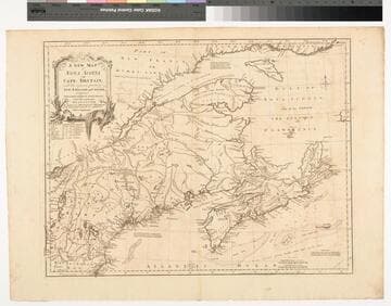
A New Map of Nova Scotia and Cape Britain. with the adjacent parts of New England and Canada, Composed from a great number of actual Surveys ; and other materials Regulated by many new Astronomical Observations of the Longitude as well as Latitude ; with an Explanation
Visual Materials
Kashnor notes, "The first issue of Jefferys' map. It was re-issued twenty years later by Sayer and Bennett." Kershaw states this is the second state of Jefferys map. Prime meridian: London, Ferro. Relief: pictorial. Graphic Scale: Miles, leagues. Projection: Pseudocylindrical. Watermark: I Ville Ary under IHS Crowned fleur-di-lis over LVC. Printing Process: Copper engraving. Other Features: Cartouche. References: Kershaw 739; McCorkle 755.20. Verso Text: MS note: 668.
105:668 M