Visual Materials
Outline map of Illinois
You might also be interested in
Map of Rancho Paso de Bartolo
Manuscripts
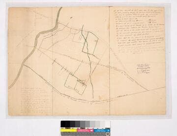
Road from Los Angeles, Road to Santa Ana, southern boundary line of Ranchito [as claimed by Bernardo Girado (?)], San Gabriel River on the western boundary. RANCHO PASO De Bartolo. Case No. stamp dated Jan. 29, 1917. Northern boundary of Rancho de los Nietos as claimed by Mr. Carpenter. Extensive notes by Hansen. Alt title supplied by cataloger.
mssSolano SR_Map_0092.01

Map of Rancho Paso de Bartolo
Manuscripts
Road from Los Angeles, Road to Santa Ana, southern boundary line of Ranchito [as claimed by Bernardo Girado (?)], San Gabriel River on the western boundary. Bordered by Rancho Santa Gertrudes. Rancho Paso De Bartolo. Case No. L.r. 77 Stamp Dated Jan. 29, 1917. Northern boundary of Rancho de los Nietos as claimed by Mr. Carpenter. Extensive notes by Hansen. Alt title supplied by cataloger.
mssSolano SR_Map_0092.02A & B
Image not available
Map of Arizona prepared specially for R. J. Hinton's hand book of Arizona
Rare Books
Shows projected routes for Southern Pacific Rail Road to the east of central Arizona. Sub map shows the existing rail road from Yuma through California. Sub map: Map of the Southern Pacific Rail Road connecting with the Central Pacific R.R. at Goshen 1877. "Compiled from Official Maps of Military Division of the Pacific Surveyor General's Office A.T. & from the notes of Col. W. G. Boyle Col. J. D. Graham, H. Ehrenberg, Prof. Pumpelly and Lieut. Philip Reade U.S.A. 1878." "Lith. Britton, Rey & Co. S.F." "Copyright secured by Richard J. Hinton." Prime meridian: GM. Relief: shaded. Graphic Scale: Miles. Projection: Pseudocylindrical. Printing Process: Lithography. Other Features: Sub-maps.
1714
Image not available
Clason's Map of Los Angeles
Rare Books
Map of central Los Angeles overprinted with half mile circles from 8th and Broadway, headquarters for Los Angeles Trust and Savings Bank, also showing branches within map area. Street index in surround. Mile and half mile concentric circles. MS note:181423. "Copyright 1919 By the Clason Map Co. of California." Prime meridian: GM. Relief: no. Projection: Plane. Printing Process: Lithography.
181423
Image not available
Base map of Illinois : prepared in cooperation with the United States Geological Survey
Visual Materials
No old shelf mark. At head of title: "State of Illinois Department of Registration and Education A.M. Shelton, Director. State Geological Survey Division. Edson S. Bastin: the Director of Registration and Education: Kendric C. Babcock of the University of Illinois: Advisors. M.M. Leighton, Chief." Prime meridian: GM. Relief: no. Graphic Scale: Miles, kilometers. Projection: Cylindrical. Printing Process: Lithography. Verso Text: MS note: Illinois.
ephMPILL0008
Image not available
Map showing railroad connections in Northern Illinois & Southern Wisconsin to accompany report of Lasalle Coal Mining Company / by H.C. Freeman C. E. Manager L.C.M. Co
Rare Books
Submap covers LaSalle IL connections between lines. MS note: X65810. Submap: Showing connection with Illinois Central R.R. Chicago & Rock Island R.R. Illinois & Michigan Canal & Illinois River. Prime meridian: GM. Relief: no. Graphic Scale: none. Projection: Cylindrical. Printing Process: Lithography.
65810