Manuscripts
Map of Rancho Paso de Bartolo

You might also be interested in
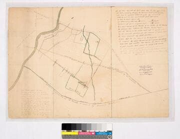
Map of Rancho Paso de Bartolo
Manuscripts
Road from Los Angeles, Road to Santa Ana, southern boundary line of Ranchito [as claimed by Bernardo Girado (?)], San Gabriel River on the western boundary. RANCHO PASO De Bartolo. Case No. stamp dated Jan. 29, 1917. Northern boundary of Rancho de los Nietos as claimed by Mr. Carpenter. Extensive notes by Hansen. Alt title supplied by cataloger.
mssSolano SR_Map_0092.01

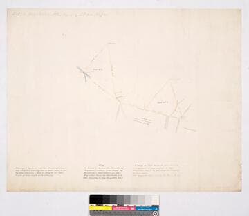
Rancho Paso de Bartolo: southern half
Manuscripts
San Gabriel River on the west (?) side. Bordered by Rancho Santa Gertrudes. Var. 13° 30'. Case No. L.r. 77 stamp dated Jan. 29, 1917. Numerous landowners indicated including Pio Pico estate. Waterways in blue; hachures, land features. Title supplied by cataloger.
mssSolano SR_Map_0093.01
Map of Lines between the lands of Thomas Phelan and that of Dunlap & Standifer in the Rancho Paso de Bartolo
Manuscripts
Rancho Paso de Bartolo. Part of a report to Superior Court of Los Angeles County dated January 18 & June 1, 1881. Color pencil highlights; features include Jacob Oil, formerly Strout, formerly Beck, Lots No. 1 & 2, Los Nietos ditch, fencing, housing; property of James King, Beck.
mssSolano SR_Map_0102

Plat of the Rancho Paso de Bartolo.; finally confirmed to Pio Pico and Juan Perez
Manuscripts
Bordered by Ranchos San Antonio, La Merced, La Puente, Santa Gertrudes; property of McFarland & Downey. Bound within document: "Field Notes and Map of the Rancho Paso de Bartolo..." (Hansen) Showing San Gabriel River, subdivided public lands, townships & section numbers, courses & distances, structures, surface details; with survey notes, table of boundaries, certification; colored inks. Alt. title supplied by cataloger.
mssSolano SR_Box_22(07).14

Paso Bartolo Zanjas: Rough Sketch of the Water courses of the Ranchito belonging to Don Pio Pico
Manuscripts
Bordered by Rancho Santa Gertrudes. Detail of upper portion of previous map including Pio Pico homestead. Case No. L.r. 77 stamp dated Jan. 29, 1917. Surveyed by request of Don Pio Pico. Waterways in blue; road from Los Angeles indicated on east (?) side. Zanja in question running to lands of L. Carpenter.
mssSolano SR_Map_0093.02

Plat of the Rancho Paso de Bartolo finally confirmed to Pio Pico
Manuscripts
Bordered by Ranchos Santa Gertrudes, San Antonio, La Merced, Potrero de Felipe Lugo, La Puente and public lands. Shows section numbers, surface details, parcel owners, structures, markers, acreage; color highlighting; has table with boundary data. Alt. title supplied by cataloger.
mssSolano SR_Box_22(06).05