Manuscripts
Rancho Paso de Bartolo: southern half

You might also be interested in

Paso Bartolo Zanjas: Rough Sketch of the Water courses of the Ranchito belonging to Don Pio Pico
Manuscripts
Bordered by Rancho Santa Gertrudes. Detail of upper portion of previous map including Pio Pico homestead. Case No. L.r. 77 stamp dated Jan. 29, 1917. Surveyed by request of Don Pio Pico. Waterways in blue; road from Los Angeles indicated on east (?) side. Zanja in question running to lands of L. Carpenter.
mssSolano SR_Map_0093.02

Map of Rancho Paso de Bartolo
Manuscripts
Road from Los Angeles, Road to Santa Ana, southern boundary line of Ranchito [as claimed by Bernardo Girado (?)], San Gabriel River on the western boundary. Bordered by Rancho Santa Gertrudes. Rancho Paso De Bartolo. Case No. L.r. 77 Stamp Dated Jan. 29, 1917. Northern boundary of Rancho de los Nietos as claimed by Mr. Carpenter. Extensive notes by Hansen. Alt title supplied by cataloger.
mssSolano SR_Map_0092.02A & B

Paso Bartolo
Manuscripts
Bordered by San Gabriel River; Rancho Santa Gertrudes. Diseño line in blue; requested by Pio Pico (indicated on map). Sketch map on back 1:20 chains, ink with pencil annotations, coordinates.
mssSolano SR_Map_0094

Map of that part of the Rancho Paso de Bartolo in the County of Los Angeles showing the partition.;(Map A)
Manuscripts
Bordered by Ranchos San Antonio, Rancho La Merced, Potrero de Felipe Lugo, La Puente, Town of Whittier. Referees in partition Alfred Solano, John E. Jackson, Thomas E. Rowan decreed by LA Superior Court Dec 27, 1893. Color highlights, hachures, landowners, roadways (Workman Mill Road), waterways indicated.
mssSolano SR_Map_0106.01
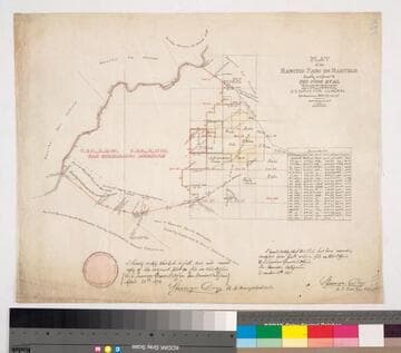
Plat of the Rancho Paso de Bartolo finally confirmed to Pio Pico et al
Manuscripts
Bordered by Ranchos Santa Gertrudes, San Antonio, La Merced, Potrero de Felipe Lugo, La Puente, San Gabriel River. Copy certified by Sherman Day, Surveyor General; Var. 15° 30' East. Inset with table of boundaries. T.2S. R.12W., T.2S. R.11W. S.B.M.
mssSolano SR_Map_0097

Map of the Puente Creek and Springs in the Rancho Paso de Bartolo
Manuscripts
Bordered by Land of Cates. Drawn by Otto V. Ploennies from Seebold's notes dated November 24, 1873. New River San Gabriel, creeks & dams; hachures indicated; waterways in blue.
mssSolano SR_Map_0099