Rare Books
Map of Arizona prepared specially for R. J. Hinton's hand book of Arizona
You might also be interested in
Image not available
Map of Arizona : prepared specially for R.J. Hinton's hand book of Arizona ; compiled from official maps of Military Division of the Pacific Surveyor General's Office A.T. & from the notes of Col. W.G. Boyle, Col. J.D. Graham, H. Ehrenberg, Prof. Pumpelly and Lieut. Philip Reade
Rare Books
Alternate title from cover. Submap: Map of the Southern Pacific Railroad connecting with the Central Pacific R.R. at Goshen 1877. Prime meridian: GM. Relief: shaded. Graphic Scale: Sections. Projection: Polyconic. Printing Process: Lithography.
42132
Image not available
Map of northwest Washington including Snoqualmie National Forest
Visual Materials
No old shelf mark. An untitled blue line map of northwest Washington up to the border with Canada. The national forests shown on the map were founded in 1908; the C.M. & St. P. R.R. (Chicago, Milwaukee and St. Paul Rail Road) was renamed the Chicago, Milwaukee, St. Paul and Pacific Rail Road in 1928. Wrapped around a tube from the U.S. Dept of Interior, Geological Survey, addressed to Col. Lawrence Martin, Chief, Division of Maps, Library of Congress, Washington, D.C. and postmarked December 11, 1934. Col. Martin visited the Huntington at about that time and made a number of recommendations regarding the map collection. Prime meridian: GM. Relief: hachures. Projection: Polyconic. Printing Process: Blue line print.
ephMPWASH0005
Image not available
Outline map of Illinois
Visual Materials
No old shelf mark. The Illinois Central Rail Road owned a good portion of the state. "Explanation. The heavy shading shows the boundary of the lands of the Illinois Central Rail Road Company within the six mile limit. The light shading the boundary of their lands within the fifteen mile limit. The red figures designate the district embraced in Sectional Map plates of corresponding number." Approximate date based on the dates of operation for the railroad lines shown. Prime meridian: GM. Relief: no. Projection: Cylindrical. Printing Process: Lithography.
ephMPILL0002
Image not available
Map of the Exploring Expedition of the Rocky Mountains in the Year 1842 and to Oregon & North California in the Years 1943-44
Rare Books
Frémont's second map showing the route from Salt Lake to California. Submap: Profile of the Route from the Mouth of the Kansas to the Pacific by Capt. J. C. Fremont in 1843.. "by Brevet Capt. J. C. Frémont of the Corps of Topographical Engineers Under the orders of Col. J. J. Abert, Chief of the Topographical Bureau." Prime meridian: GM. Relief: hachures. Graphic Scale: Miles. Projection: Polyconic. Printing Process: Lithography. Other Features: Sub-maps.
116680
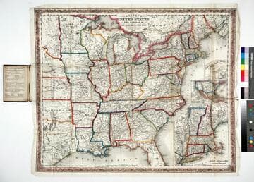
Colton's map of the United States, the Canadas &c showing the rail roads, canals & stage roads with distances from place to place
Rare Books
Kirkpatrick Catalogue entry: "2463 Colton, J. H., publisher. Colton's map of the United States, the Canadas &c. showing the rail roads, canals, & stage roads ... New York, J. H. Colton, 1860. 1 sheet. [see p.]."Alternate title from cover. Submaps: Map of New England and Eastern New York; Map of the United States & Central America; The Isthmus of Panama showing the Routes of Travel between Aspinwall & Panama. . Prime meridian: GM, Washington. Relief: hachures. Graphic Scale: Miles. Projection: Polyconic. Printing Process: Lithography. Other Features: Sub-maps. Verso Text: MS note: R.B. 11486, i Stamp: Kensington Public Libraries.
623637
Image not available
Map of Flavel, Clatsop Co. Oregon
Rare Books
A real estate sales map for an area close to Astoria, Oregon, now probably names Fort Stevens. Sub map shows the mouth of the Columbia River. See also 150223 for another copy bearing information on the verso about Flavel. Sub map: Key Map of mouth of the Columbia River. Key Map note: Hydrography from a Survey made by the Corps of Engineers, U.S.A., in May-June, 1895. "Property of the Flavel Land & Development Co. S. H. Brown Jr, President, Boston, Mass., J. M. Turney, Secretary, Flavel, Oregon." Relief: no. Graphic Scale: Feet. Projection: Plane. Printing Process: Lithography. Other Features: Sub-maps. Verso Text: MS notes: No. 62 150197 F1/1.
150197