Rare Books
A map of America or the New World : wherein are introduced all the known parts of the Western Hemisphere from the map of D'Anville with the necessary alterations and the addition of the discoveries made since the year of 1761
You might also be interested in
Image not available
Bowles's new pocket map of North America : divided into it's provinces, colonies, states, &c. / by J. Palairet, geographer lately revised and improved with many additions from D'Anville, Mitchel, & Bellin. by L. Delarochette
Rare Books
Gift of Mrs. Homer Crotty, November 1991 MS notes: EE 3 50 5.00. Prime meridian: Ferro. Relief: pictorial. Graphic Scale: Miles. Projection: Dual Hemisphere. Watermark: Crowned device VI. Printing Process: Copper engraving. Verso Text: MS notres: Bowles North America 493932.
493932
Image not available
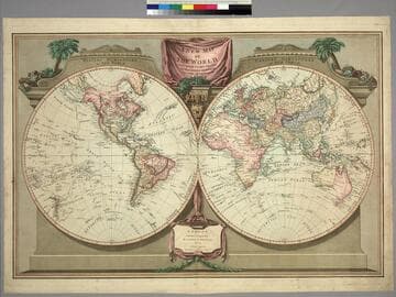
Map of the World, with the latest Discoveries, by Samuel Dunn, Mathematician
Visual Materials
Kashnor notes,"Shows a good coastline of North-West America, evidently taken from Cook, whose tracks are given. Australia and New Zealand are shown complete." Undefined land no. of Siberia labeled "Plenstner's Land." Numeral 1, upper right and lower right.. Prime meridian: Ferro. Relief: pictorial. Graphic Scale: No. Projection: Dual Hemisphere. Printing Process: Copper engraving. Verso Text: MS. notes: #93 43. The World..
093:043 M
Image not available
New Map of the World, with Captain Cook's Traacks, His Discoveries and Those of the Other Circumnavigators
Visual Materials
Kashnor notes, "Shows all the west coast and locates the Oregon River,Vancouver's discoveries, and it is one of the earliest English maps to locate Great Salt Lake under the name of Nadonessis." Decorative surround.. Prime meridian: Ferro. Relief: pictorial. Projection: Dual Hemisphere. Printing Process: Copper engraving. Verso Text: MS note: 560.
093:560 M
New Map of the World, with Captain Cook's Tracks, his Discoveries and those of the other Circumnavigators
Visual Materials
Kashnor notes, "Locates San Francisco, P. Sir Francis Drake, Port Diego, and Monterey Bay; also the Oregon River." See 105:048 for an earlier version (1794). Vancouver Island now appears and Tasmania is separated. Prime meridian: Ferro. Relief: no. Graphic Scale: No. Projection: Dual Hemisphere. Printing Process: Copper engraving. Verso Text: MS note: 271.
105:271 M
Image not available
New Map of the World, with Captain Cook's Tracks, his Discoveries and those of the other Circumnavigators
Visual Materials
Kashnor notes, "Probably the last map issued before the discoveries of Vancouver and La Perouse. Locates New Albion, Drake's Harbor, Port Monterey, Dixon's Strait, Nootka and Fuca Entrance." See 105:271M for a later version (1812). Prime meridian: Ferro. Relief: no. Graphic Scale: No. Projection: Dual Hemisphere. Printing Process: Copper engraving. Verso Text: MS note: 48.
105:048 M
Image not available
A New and Accurate Map of the Known World
Visual Materials
Kashnor notes, "Represents New Guinea as a peninsula, and marks "Holy Ghost Land," i.e. part of the north-eastern extremity of Australia." [In the western hemisphere it is called Tierra de Espirita Sancto.] Kashnor dates as ca. 1720. Cartouche: leaves & pediments Vignettes: Four continents depicted as seated female figures. Depiction of world without water, lower margin.. "Drawn from the latest & most Authentic Surveys assisted by the best & most approved Modern Maps Charts &c. Wherein all the late Discoveries & Improvemts. are carefully Delineated. The whole being Regulated by Astron. Observations by Eman. Bowen." Prime meridian: Ferro. Relief: pictorial. Projection: Dual Hemisphere. Printing Process: Copper engraving. Other Features: CartoucheVignettesFigures . Verso Text: MS note: 982.
105:982 S