Visual Materials
A New and Accurate Map of the Known World
You might also be interested in
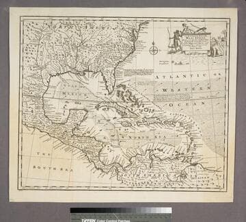
An Accurate Map of the West Indies
Visual Materials
Kashnor notes, "Includes Florida, Georgia, Carolina, Virginia, and Maryland. Also shows the coast of New Leon and present-day Texas." Kashnor dates as ca. 1767. RLIN record suggests 1747. Cartouche: Natives & Lion.. "Drawn from the best Authorities, assisted by the most approved Modern Maps and Charts, and regulated by Astronomical Observations. By Eman. Bowen." Prime meridian: London. Relief: pictorial. Graphic Scale: Miles. Projection: Azimuthal. Printing Process: Copper engraving. Other Features: Cartouche. Verso Text: MS note:943.
105:943 S
Image not available
A New and Accurate Map of Peru, and the country of the Amazones
Visual Materials
Kashnor notes, "Indicates Parima Lake and the famour city of El Dorado two degrees North of the Equator." Kashnor dates as ca. 1760. RLIN record suggests 1747 as publication data. Cartouche: Decorative shell.. "Drawn from the most authentick French Maps &c. and Regulated by Astronomical Observations. By Eman. Bowen." "No. 118 (lower left)" Prime meridian: London. Relief: pictorial. Graphic Scale: Leagues. Projection: Pseudocylindrical. Printing Process: Copper engraving. Other Features: Cartouche. Verso Text: MS note: 933.
105:933 M
Image not available
A New and Accurate Map of Paraguay, Rio de la Plata, Tucumania Guaria &c
Visual Materials
Kashnor notes, "Shows a note on the Jesuit settlement in Paraguay, said to contain about 300,000 families." Kashnor dates as ca. 1760. RLIN record suggests a date of 1747. Cartouche: Indians and traders.. "Laid down from the latest Improvements, and Regulated by Astronomical Observations, by Eman Bowen." "No. 127 (lower left)" Prime meridian: London. Relief: pictorial. Graphic Scale: Miles. Projection: Azimuthal. Printing Process: Copper engraving. Other Features: Cartouche. Verso Text: MS note: 926.
105:926 M
Image not available
A New and Accurate Map of the Islands of Newfoundland, Cape Briton, St. John and Anticosta; together with the neighboring Countries of Nova Scotia, Canada &c
Visual Materials
"Drawn from the most approved Modern Maps and Charts, and Regulated by Astront. Observatns. by Eman Bowen." Variant of 093:262. Kashnor dates as ca. 1752. Kershaw identifies this as the first state of Bowen's map, published in 1747. Prime meridian: London. Relief: pictorial. Graphic Scale: Miles. Projection: Pseudocylindrical. Printing Process: Copper engraving. Other Features: Cartouche. References: Kershaw 693; LC Phillips 603. Verso Text: MS note: 561.
105:561 M
Image not available
New and Accurate Map of the World Drawn from the latest Observations
Visual Materials
Kashnor notes, "This is the same as Map 38 [105:038M] Mappe Monde, with the names and notes in English. Shows the North-West Coast and the South Seas immediately before the discoveries of Cook on his first voyage, but showing the coast of Alaska as found by the Russians. This was copied from Palariet's map." See 105:039M for rework of this map by Robert de Vaugondy in 1783. Note this map is slightly smaller than 105:038M and lacks border of original map. Climate zones shown Eastern Hemisphere. Antipodes on Western Hemisphere.. Prime meridian: Ferro. Relief: no. Graphic Scale: No. Projection: Dual Hemisphere. Printing Process: Copper engraving. Verso Text: MS notes: 42 H5.
105:042 M

A New and Accurate Map of Terra Firma and the Caribbe Islands
Visual Materials
Kashnor dates [circa 1714]. RLIN record suggests publication date as 1747. Cartouche: leaves.. "Drawn from the most approved Modern Maps & Charts, & adjusted by Astron. Observatns. By Eman. Bowen." Prime meridian: London. Relief: pictorial. Graphic Scale: Miles. Projection: Conic. Printing Process: Copper engraving. Other Features: Cartouche. Verso Text: MS note: 959.
105:959 M