Rare Books
A map of ye English Empire in ye continent of America : viz Virginia, Maryland, Carolina, New York, New Jarsey, New England, Pennsilvania
You might also be interested in
Image not available
Map of ye English Empire in ye continent of America : viz Virginia, Maryland, Carolina, New York, New Jarsey, New England &ct. / by R. Daniel, Esqr
Rare Books
Reproduction. 1st state: Daniel's name appears in the cartouche. A lithographic reproduction of an old map, including the seal of the British Museum [Library] of 1897 on the original. Surround is a description of English colonies then existent. The paper used make has been printed with wire lines and watermark as might have been used on the original that can be seen from both sides of the paper. See 71000 for a reproduction of the 2nd state of this map, and 71005 for an original of the 2nd state. This copy has a British Museum Stamp. MS note: X70999. Prime meridian: London. Relief: pictorial. Graphic Scale: Miles. Projection: Pseudocylindrical. Watermark: Windmill. Printing Process: Lithography.
70999

A map of ye English Empire in ye continent of America : viz Virginia, Mary Land, Carolina, New York, New Iarsey, New England, Pennsilvania. Sold by R. Morden at ye Atlas in Cornhill neer ye Royal Exchange London. W.Binneman sculpsit
Rare Books
Alternate title from head of text. This is state 2 of the map, as identified by Burden. See 71000 for a reproduction of the 2nd state of this map, 70999 for a reproduction of the 1st state of this map. Surround with many notes, starting "The designe of this map is to divert one common and notorious Abuse that the Dutch and French (whose Maps being the fondlings of this age) have imposed upon us..." Folder also contains a rather comprehensive description of the map addressed to Chester M. Cate, Huntington Library from Henry N. Stevens, Map and Book dealer, London. Submap: Virgina south to Florida. MS note: X71005. Prime meridian: GM. Relief: pictorial. Graphic Scale: Miles. Projection: Pseudocylindrical. Printing Process: Copper engraving. References: Burden, map 514. Verso Text: MS note: 71005.
71005
Image not available
A New Map of the English Empire in America viz Virginia, New York [etc.]. Revised by Jon Senex, 1719
Visual Materials
Kashnor notes, "a rare and important map." This is the second & last state of the Morden map, see 105:541M, only the cartouche is changed. Cartouche surmounted by dedication. Submaps: The Harbour of Boston or Massachusetts Bay; A General map of the Coasts and Isles of Europe, Africa, and America. "I. Harris sculp: Dedication: Most humbly Inscrib'd ti Herver Edgly Herver of Clapham Esq. &c." Prime meridian: London. Relief: pictorial. Graphic Scale: Miles. Projection: Pseudocylindrical. Watermark: Fleur-di-lis. Printing Process: Copper engraving. Other Features: Sub-mapsCartouche. References: Tooley (Amer) p.63, #20. Verso Text: MS note: 542.
105:542 M
Image not available
A New Map of New England. New York. New Jarsey. Pensilvania. Maryland. and Virginia. by Philip Lea in Cheap-side London
Visual Materials
Kashnor notes: "An exceedingly rare map locating as far up the Hudson River as New Albanie; locates Fort Elsinborough on the Delaware, and takes in the coast from Cape Henry to Boston." McCorkle states this is a later state of Lea's 1680 map, which the British Library says is from 1686, similar to Kashnor's dating. Kashnor dates as ca. 1686. Atlantic Ocean is named "Sea of the English Empire." Submap: Entry to New York Harbor.. Relief: pictorial. Graphic Scale: Miles. Projection: Cylindrical. Watermark: II. Printing Process: Copper engraving. Other Features: Sub-maps. References: McCorkle 680.4. Verso Text: MS notes: 105/582.
105:582 M
Image not available
A New Chart of the English Empire in North America
Rare Books
Four sheet reproduction from the copy in the John Carter Brown Library. Original map published by Fra. Dewing in Boston. Reproduction published by John Carter Brown Library in Providence, R.I. Earliest printed map in the United States per cover sheet with map. Index of features. Relief: pictorial. Graphic Scale: Miles. Projection: Cylindrical. Printing Process: Lithography.
247346
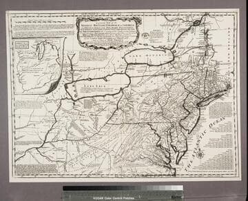
A general map of the middle British Colonies, in America : viz Virginia, Maryland, Delaware, Pensilvania, New-Jersey, New-York, Connecticut, and Rhode Island ; of Aquanishuonigy the country of the Confederate Indians, comprehending Aquanishuonigy proper, their places of residence, Ohio and Thuchsochruntie their deer hunting countries, Couchsahrage and Skaniadarade, their beaver-hunting countries ; of the Lakes Erie, Ontario and Champlain, and of part of New-France ; wherein is also shewn the antient and present seats of the Indian Nations ; carefully copied from the original publish'd at Philadelphia / by Mr. Lewis Evans 1755, with some improvements by I. Gibson
Rare Books
Reproduction. This appears to be the earliest plagiarism of Evans map. Kitchin made a new plate incorporating Evans' map but eliminating the dedication and replacing it with words from Evans' Analysis (see Preface). Several other statements are also lifted from that source, but in some cases abridged, to show the French as usurpers of British territory. This appears to be the only photo-reproduction in this set of maps, the rest being original copper plate engravings. Note slightly wider but also shorter than 18213. Pownall in his later discussion thought this variant was first done by Thomas Jefferys and criticized the haphazard mountains and poorer engraving. See 18215 by Jefferys from same plate. Submap: A sketch of the Remaining part of the Ohio R., &c. MS note: 18214 Stamp: British Museum, 6 April 1892. Prime meridian: London, Philadelphia. Relief: pictorial. Graphic Scale: Miles. Projection: Pseudocylindrical. Printing Process: Photographic reproduction. Verso Text: Stamped: III. MS notes: Shelve with #18212 Evans, Lewis ; #18214.
18214