Rare Books
Cruchley's new plan of London improved to 1829 including the East and West India Docks

You might also be interested in
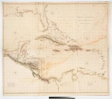
Chart of the West Indies and Spanish Dominions in North America. by A. Arrowsmith 1803. Hydrographer to H. R. H. the Prince of Wales. Additions to 1810 --1815
Visual Materials
Kashnor notes, "Amongst other interesting particulars, this map indicates the positions of the canals proposed to be cut by the Spaniards in 1528. The original issue of Arrowsmith's map, valuable for the detail regarding the coast of present-day Texas and the colonies of New Santander." Note from 105:948, another copy. Prime meridian: London. Relief: hachures. Projection: Cylindrical. Printing Process: Copper engraving. Verso Text: MS note: 715 XII XIII.
093:715 M

Elementary Drawing Book; A Series of Easy Progressive Lessons for Young Beginners, New and Improved Edition, No. VIII
Visual Materials
One drawing book entitled Elementary Drawing Book; A Series of Easy Progressive Lessons For Young Beginners, New and Improved Edition, No. VIII, by George Childs, published by David Bogue, London, ca. 1875. This drawing book is comprised of four lithograph plates, numbered 25-28. The title and publisher's information on the front cover are framed by a floral, decorative border. "Price nine pence" is printed in the upper right hand corner, opposite the volume number. "B. Clarke, Printer" is printed in the lower left-hand corner of the front cover. At the bottom of the first plate is printed "Tilt & Bogue, Fleet Street, London. J.R. Jobbins, Zinco." Each of the four plates are untitled and contain two separate views per leaf, side by side. Some of the views include human figures. There are no textual instructions, and there is no space provided for copying. The back cover is a publisher's advertisement for "New and Superior Drawing Books".
ephKAEE

A map of the new governments, of east & west Florida
Visual Materials
Kashnor notes, "a scarce map." Kashnor dates as ca. 1760. Gentleman's Magazine published in London. Submap of Pensacola Harbor. West Florida extends to Mississippi River. Submap: Plan of the Harbour and Settlement of Pensacola. Prime meridian: London. Graphic Scale: Miles. Projection: Pseudocylindrical. Printing Process: Copper engraving.
093:388 S
Image not available
Provinces of New York, and New Jersey; with part of Pensilvania, and the Province of Quebec
Visual Materials
Three submaps. Appeared in informaqtion from RLIN record. Cartouche: River Scene. Submaps: Chart of the mouth of Hudson's River, from Sandy Hook to New York; Plan of Amboy, With its Environs, from an actual survey; Plan of the City of New York.. " Drawn by Major Holland, Surveyor General, of the Northern District in America. Corrected and improved from the Original Material, by Govern. Poiwnell, Member of Parliament 1776." Prime meridian: London. Relief: pictorial. Graphic Scale: Miles, leagues. Projection: Cylindrical. Printing Process: Copper engraving. Other Features: Sub-maps. Verso Text: MS note: 592.
105:592 M
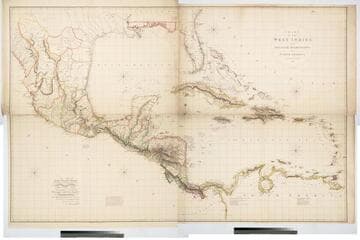
Chart of the West Indies and Spanish Dominions in North America. By A. Arrowsmith 1803
Visual Materials
Kashnor notes, "Amongst other interesting particulars, this map indicates the positions of the canals proposed to be cut by the Spaniards in 1528. The original issue of Arrowsmith's map, valuable for the detail regarding the coast of present-day Texas and the colonies of New Santander." " Jones Smith & Co. sc. Beaufort Build'gs Strand." "To Admiral John Willett Payne, A distinguished Native of the West Indies. Vice Admiral of the Coasts of Devonshire & Cornwall, Treasurer of Greenwich Hospital, Comptroller General of the Household of the Prince, &c., &c., &c. This chart is respectfully Dedicated by his most obedient Serv't A. Arrowsmith." Prime meridian: London. Relief: hachures. Projection: Cylindrical. Printing Process: Copper engraving. Verso Text: MS note: 795.
105:795 M

Plan of the City of New-York & its Environs to Greenwich, on the North or Hudsons River, and to Crown Point, on the East or Sound River
Rare Books
Very detailed map of the City at the start of the American Revolution. See 150238 for two additional copies. Submap: Chart of the Entrance to New York from Sand Hook showing the properest Channel, for Sailing with the Banks and depths of Water.. "Showing the Several Streets, Publick Buildings, Docks, Fort & Battery, with the true Form & Course of the Commanding Grounds, with and without the Town." "To the Hon'ble Thos. Gage, Esqr. Major General and Commander in Chief of his Majesty's Forces in North America and Colonel of the 22d Regiment of Foot. This plan is most humbly Inscribed by his Obedient Servant. John Montresor. Engineer. R. Andrews Sculp." Prime meridian: GM. Relief: hachures. Graphic Scale: Feet, Miles. Projection: Plane. Printing Process: Copper engraving. Other Features: Sub-maps.
12036