Rare Books
Map of the city of San Marino, Los Angeles County, California / compiled from county records by William Chalmers - City Engineer
You might also be interested in
Image not available
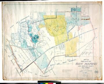
Map of the City of San Marino Los Angeles County California / compiled from County Records by William Chalmers - City Engineer
Rare Books
"The City of San Marino was incorporated as a city of the Sixth Class on the 25th of April 1913." Lists City Officers. Covers the area from Milan Street on the west, Rose Avenue (San Gabriel Blvd.) on the east, San Pasqual St. on the north, Alhambra Road to the south. See map 234876 for a larger, later version of this map. Relief: no. Graphic Scale: Feet. Projection: Plane. Printing Process: Blueline print.
251107
Map of the city of San Marino, Los Angeles County, California
Rare Books
"Scale 1 inch = 300 feet." "The City of San Marino was incorporated as a City of Sixth Class on the 25th day of April 1913 ..." Prime meridian: GM. Relief: no. Graphic Scale: Feet. Projection: Cylindrical. Printing Process: Blue line print. Verso Text: MS notes: City of San Marino Los Robles Ranch colored.
477773
Image not available
Map of the City of San Marino Los Angeles County California compiled from County Records / by William Chalmers - City Engineer
Rare Books
Covers the area from Milan Street on the west, Rose Avenue (San Gabriel Blvd.) on the east, San Pasqual St. on the north, Alhambra Road to the south. See map 251107 for a smaller, earlier version of this map. Relief: no. Graphic Scale: Feet. Projection: Plane. Printing Process: Blueline print.
234876
Image not available
Aerial survey city of San Marino in the County of Los Angeles California
Rare Books
Aerial survey map of San Marino. Photograph pasted on paper with linen backing. Projection: Plane. Printing Process: Photograph. Verso Text: MS notes: San Marino City Aerial View.
371749
Image not available
Aerial survey city of San Marino in the County of Los Angeles California
Rare Books
Aerial survey map of San Marino. Photograph pasted on paper with linen backing. Projection: Plane. Printing Process: Photograph. In wooden frame.
60.1.14
Image not available
City of Watts : Los Angeles County California ; being a portion of Rancho Tajauta / map compiled from records by L.D. House City Engineer
Rare Books
Blue line tract map before Watts became part of the City of Los Angeles. Relief: no. Graphic Scale: Feet. Projection: Plane. Printing Process: Diazo print.
386276