Rare Books
Bridewell's map of northwest Los Angeles / compiled, copyrighted and sold by W.E. Bridwell Engineering Company
You might also be interested in
Image not available
Bridewell's Map of South Section / Compiled, Published and for sale by W. E. Bridewell Engineering Co. 804 So. Vermont Av. Los Angeles , Cal. Copyrighted
Rare Books
"Compilers and Publishers of City, County, State and Legal Maps with patented street finder." Wall map of El Segundo - Lynwood south to Los Angeles Harbor. Hand colored designation numbers. See 477333 for northern extension of this map. Prime meridian: GM. Relief: no. Graphic Scale: Miles. Projection: Cylindrical. Printing Process: Blueline print. Verso Text: MS note: 268914 Huntington Label.
268914
Image not available
Bridwell's Map of Los Angeles
Rare Books
Wall map of Los Angeles as far south as El Segundo. Hand colored designation numbers. See 268914 for southern extension of this map. Prime meridian: GM. Relief: no. Graphic Scale: Miles. Projection: Cylindrical. Printing Process: Blueline print.
477333
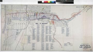
Industry map of Los Angeles
Rare Books
At head of title: "Southern Pacific Company ; Pacific System." An index of companies using various terminals, spurs and junctions. Shows tracks of SP, RE, AT&SF, LA Ry. Tables of industrial companies. Prime meridian: GM. Relief: no. Graphic Scale: Feet. Projection: Plane. Printing Process: Blueline print. Verso Text: MS note: Map Southern Pacific System Los Angeles.
373508
Image not available
Map of the City of San Marino Los Angeles County California compiled from County Records / by William Chalmers - City Engineer
Rare Books
Covers the area from Milan Street on the west, Rose Avenue (San Gabriel Blvd.) on the east, San Pasqual St. on the north, Alhambra Road to the south. See map 251107 for a smaller, earlier version of this map. Relief: no. Graphic Scale: Feet. Projection: Plane. Printing Process: Blueline print.
234876
Image not available
Map of the City of San Marino Los Angeles County California / compiled from County Records by William Chalmers - City Engineer
Rare Books
"The City of San Marino was incorporated as a city of the Sixth Class on the 25th of April 1913." Lists City Officers. Covers the area from Milan Street on the west, Rose Avenue (San Gabriel Blvd.) on the east, San Pasqual St. on the north, Alhambra Road to the south. See map 234876 for a larger, later version of this map. Relief: no. Graphic Scale: Feet. Projection: Plane. Printing Process: Blueline print.
251107
Image not available
Map of the property to be sold at auction Saturday, Jan 23rd, 1886 by order of Los Angeles Improvement Co. sale peremptory
Visual Materials
Old shelf number: eph J5-2(2). A photocopy showing the area west of two previous maps. Lake Shore Avenue is today's Glendale Blvd. Prime meridian: GM. Relief: no. Graphic Scale: Feet. Projection: Plane. Printing Process: Lithography. Verso Text: Ms note: Eph J5-2(2). 625 negative and print Map of the property... Sticker: Map showing property to be sold at auction Jan 23, 1886 L.A. Improvement Co. Builders of 2nd St. Cable Co.
ephMPCALIFT0121