Visual Materials
Poli Arctici : et circumiacentium terrarum descriptio novissima sumptibus / Henrici Hundy

You might also be interested in
Image not available
Virginiae partis australis ; et Floridae partis orientalis ; interjacentiumque regionum nova descriptio
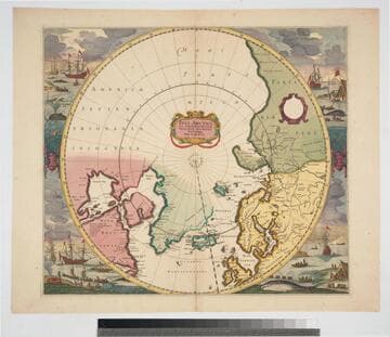
Visual Materials
Kashnor dates ca. 1630. Cumming dates 1638. A comparison with van der Krogt and Burden shows that the author is Jansson, not Blaeu, and was published in an edition of his Novus atlas between 1630 and 1675. Cartouche: Indian figures. Prime meridian: Ferro. Relief: pictorial. Graphic Scale: Milliaria? Projection: Cylindrical. Printing Process: Copper engraving. References: Burden 254; Cumming 42; Van der Krogt, map 9400:1B Verso Text: MS note: 595.
093:595 M
Image not available
Virginae item et Floridae : Americae provinciarum, nova descriptio
Visual Materials
Kashnor notes, "A scarce map, and one of the highly decorative type, richly colored. It is Gerhard Mercator's issue of Captain John Smith's map, published by Hondius." Kashnor dates as 1630, Rosenthal suggests [1606-1616]. Given pagination and language of verso, Burden dates at 1619 (entry 151). Editor and edition information taken from Van der Krogt (1:113). Two villages in cartouche; figures; indian canoe. Photocopy filed with map. "Civitatum Floridae imitatio; Civitatum Virginiae forma. [above two village views]" Prime meridian: Ferro. Relief: pictorial. Projection: Mercator. Printing Process: Copper engraving. Verso Text: Pages 371, 372, Dddddddd. Virginae et La Floride. French description.
105:824 M
Image not available
Nova Anglia Novum Belgium et Virginia
Rare Books
State 1 of this map, according to Burden (map 247); date based on language and signature on verso (Van der Krogt, map 9310:1A.1). Both Hondius and Jansson published Nouveau theatre du monde, Hondius from 1639-42 and Jansson from 1639-1644. Verso bears atlas pages in French. Excerpted from Nouveau theatre du monde... published in Amsterdam by H. Hondius in 1639. Cartouche: vines & shells. Relief: pictorial. Graphic Scale: Miles. Projection: Cylindrical. Printing Process: Copper engraving. Verso Text: Unnumbered (but bearing the signature ddddd) atlas pages in French. MS notes: 32292 1172 1. 11.1 4/5 150043.
150043
Image not available
Nova Virginiae tabula
Visual Materials
Kashnor notes, "Very rare. The cartographer follows the map of Captain John Smith, published in 1612. The next after the above map was again issued by Smith in his Virginia Discovered, 1625." Kashnor dates as 1619, but he seems to have confused this with Jodocus Hondius Jr.'s map of the same name. According to Burden this is State 1, and dates to 1630 (Burden, map 193; Van der Krogt, map 9410:1). For a later edition of the Hondius map, see RB 150037; for Keere's version of the map, see RB 150048; for Blaeu's version of the map, see RB 150054; for Montanus's version of the map, see 150077. Figure of Indian below English coat of arms; Scene of Chief of the Powhatans. Relief: pictorial. Graphic Scale: Miles, German. Projection: Cylindrical. Printing Process: Copper engraving. Verso Text: MS note: 823.
105:823 M
Poli Arctici, et circumiacentium terrarum descriptio novissima / per F. de Wit
Visual Materials
Kashnor notes, "Shows Hudson's Bay before the advent of the Company. The map followed that given by Capt. Thomas James." Kashnor dates as "c. 1670." Canadian archives date map to 1715. Whaling and sealing scenes each corner, beautifully colored. Prime meridian: Ferro. Relief: no. Projection: Polar. Printing Process: Copper engraving. Verso Text: MS notes: 242 C16u.
093:242 M

Nova et accuratissima totius terrarum orbis tabula / auctore Joanne Blaeu
Visual Materials
Kashnor notes, "Shows California as an island, and places "Anian" considerably to the north. A fascinating old map of the early decorative type." This map is a variant of Blaeu's 1662 map, Kashnor dates as 1667. Van der Krogt dates between 1662 and 1672. Map can be seen in situ in RB 74701. Surrounded by artwork, allegorical figures. MS note: C26. Folder contains reproduction as well. Prime meridian: Tenerife. Relief: no. Projection: Dual Hemisphere. Printing Process: Copper engraving. References: Van der Krogt, map 0001:2B ; Shirley, map 428.
105:284 M