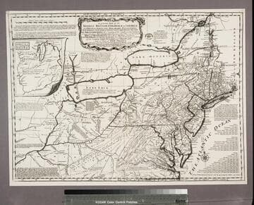
Rare Books
A general map of the middle British Colonies, in America; viz Virginia, Màriland, Dèlaware, Pensilvania, New-Jersey, New-York, Connecticut, and Rhode Island: of Aquanishuonîgy, the country of the Confederate Indians; comprehending Aquanishounîgy proper, their place of residence, Ohio and Tïiuxsoxrúntie their deer-hunting countries, Couxsaxráge and Skaniadaráde, their beaver-hunting countries; of the Lakes Erie, Ontário and Champlain, and of part of New-France: wherein is also shewn the antient and present seats of the Indian Nations / by Lewis Evans 1755

You might also be interested in
A general map of the middle British Colonies, in America : viz Virginia, Maryland, Delaware, Pensilvania, New-Jersey, New-York, Connecticut, and Rhode Island ; of Aquanishuonigy the country of the Confederate Indians, comprehending Aquanishuonigy proper, their places of residence, Ohio and Thuchsochruntie their deer hunting countries, Couchsahrage and Skaniadarade, their beaver-hunting countries ; of the Lakes Erie, Ontario and Champlain, and of part of New-France ; wherein is also shewn the antient and present seats of the Indian Nations ; carefully copied from the original publish'd at Philadelphia / by Mr. Lewis Evans 1755, with some improvements by I. Gibson
Rare Books
Reproduction. This appears to be the earliest plagiarism of Evans map. Kitchin made a new plate incorporating Evans' map but eliminating the dedication and replacing it with words from Evans' Analysis (see Preface). Several other statements are also lifted from that source, but in some cases abridged, to show the French as usurpers of British territory. This appears to be the only photo-reproduction in this set of maps, the rest being original copper plate engravings. Note slightly wider but also shorter than 18213. Pownall in his later discussion thought this variant was first done by Thomas Jefferys and criticized the haphazard mountains and poorer engraving. See 18215 by Jefferys from same plate. Submap: A sketch of the Remaining part of the Ohio R., &c. MS note: 18214 Stamp: British Museum, 6 April 1892. Prime meridian: London, Philadelphia. Relief: pictorial. Graphic Scale: Miles. Projection: Pseudocylindrical. Printing Process: Photographic reproduction. Verso Text: Stamped: III. MS notes: Shelve with #18212 Evans, Lewis ; #18214.
18214

A general map of the middle British Colonies, in America : viz. Virginia, Maryland, Delaware, Pensilvania, New-Jersey, New York, Connecticut & Rhode Island ; of Aquanishuonigy, the country of the Confederate Indians comprehending Aquanishuonigy proper, their places of residence, Ohio & Thuchsochruntie their deer-hunting countries, Couchsachrage and Skaniadarade, their beaver-hunting countries ; of the Lakes Erie, Ontario and Champlain ; wherein is also shewn the antient & present seats of the Indian Nations ; carefully copied from the original publish'd at Philadelphia / by Mr. Lewis Evans
Rare Books
This map is the same as 18218 with alteration of the imprint and exact dating. The second 1771 issue is map 18220, bearing some alterations explained there. Submap: A sketch of the Remaining part of the Ohio R., &c. MS note: 18219. Prime meridian: London, Philadelphia. Relief: pictorial. Graphic Scale: Miles. Projection: Pseudocylindrical. Printing Process: Copper engraving. Verso Text: Stamped: VIII. MS notes: Shelve with #18212 Evans, Lewis ; #18219.
18219

A general map of the middle British colonies in America : viz. Virginia, Maryland, Delaware, Pensilvania, New-Jersey, New-York, Connecticut and Rhode Island ; of Aquanishuonigy, the country of the confederate indians comprehending Aquanishuonigy proper, their places of residence, Ohio and Thuchsochruntie, their deer hunting countries, Couchsachrage and Skaniadarade, their beaver hunting countries ; of the Lakes Erie, Ontario and Champlain ; exhibiting the ancient and present seats of the indian nations
Rare Books
Lots of explanatory notes scattered across the map. McCorkle describes this as a Kitchin piracy of the Evans map of 1755. Huntington has multiple editions of this map in its holdings. Prime meridian: London, Philadelphia. Relief: pictorial. Graphic Scale: Miles. Projection: Polyconic. Printing Process: Copper engraving. Verso Text: MS note: Middle British Colonies No. 9. References: McCorkle map 756.4.
480577

A general map of the middle British Colonies, in America : viz. Virginia, Maryland, Delaware, Pensilvania, New-Jersey, New York, Connecticut & Rhode Island ; of Aquanishuonigy, the country of the Confederate Indians comprehending Aquanishuonigy proper, their places of residence, Ohio & Thuchsochruntie their deer-hunting countries, Couchsachrage and Skaniadarade, their beaver-hunting countries ; of the Lakes Erie, Ontario and Champlain ; wherein is also shewn the antient & present seats of the Indian Nations ; carefully copied from the original publish'd at Philadelphia / by Mr. Lewis Evans
Visual Materials
Kashnor notes, "This is the eighth issue of Lewis Evans' map. The territory of Ohio is named above and below the river, with the inset showing the remaining parts of Ohio." Many notes on Indian tribes. Prime meridian: London, Philadelphia. Relief: pictorial. Graphic Scale: Miles. Projection: Pseudocylindrical. Printing Process: Copper engraving. Verso Text: MS notes: 3 A General Map of Middle British Colonies in America. Map of the Lakes & Middle Colonies by Evans.
093:526 M

A general map of the middle British Colonies, in America : viz Virginia, Maryland, Delaware, Pensilvania, New-Jersey, New-York, Connecticut, and Rhode Island ; of Aquanishuonigy, the country of the Confederate Indians, comprehending Aquanishuonigy proper, their places of residence, Ohio and Thuchsochruntie their deer-hunting countries, Couchsachrage and Skaniadarade, their beaver-hunting countries ; of the Lakes Erie, Ontario and Champlain, and of part of New-France ; wherein is also shewn the antient and present seats of the Indian Nations; carefully copied from the Original Publish'd at Philadelphia, By Mr. Lewis Evans 1755, with some improvements by I. Gibson
Rare Books
This is a copy of the Kitchin map of 1756 with Kitchin's name altered to that of Jefferys, hence a plagairism of a plagairism of Evans map. Jefferys has added several new forts and has changed Kitchin's "F. du Quesne" to "Ft. du Quesne, Destroy'd in 1758 now called Pittsburg." Pownall in his later discussion thought this variant was first done by Thomas Jefferys. Submap: A sketch of the Remaining part of the Ohio R., &c. MS note: 18215. Prime meridian: London, Philadelphia. Relief: pictorial. Graphic Scale: Miles. Projection: Pseudocylindrical. Printing Process: Copper engraving. Verso Text: Stamped: IV. MS notes: Shelve with #18212 Evans, Lewis ; #18215.
18215

A general map of the middle British Colonies, in America : viz. Virginia, Maryland, Delaware, Pensilvania, New-Jersey, New-York, Connecticut and Rhode Island ; of Aquanishuonigy, the country of the Confederate Indians comprehending Aquanishuonigy proper, their places of residence, Ohio & Thuchsochruntie their deer-hunting countries, Couchsachrage and Skaniadarade, their beaver-hunting countries ; of the Lakes Erie, Ontario and Champlain ; exhibiting the antient & present seats of the Indian Nations / published by Lewis Evans at Philadelphia ; corrected and improved with the additions of the line of forts on the back settlements ; by Thos. Jefferys Geographer to the King
Rare Books
This is a reissue of the Jefferys map of 1758, Huntington 18217. Note the date of publication has been changed to 1775, otherwise identical. Submap: A sketch of the Remaining part of the Ohio R., &c. MS note: 18221. Prime meridian: London, Philadelphia. Relief: pictorial. Graphic Scale: Miles. Projection: Pseudocylindrical. Printing Process: Copper engraving. Verso Text: Stamped: X. MS notes: Shelve with #18212 Evans, Lewis ; #18221.
18221