Rare Books
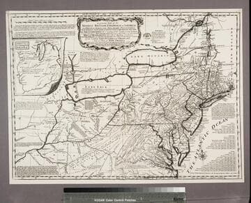
A general map of the middle British Colonies, in America : viz. Virginia, Maryland, Delaware, Pensilvania, New-Jersey, New-York, Connecticut and Rhode Island ; of Aquanishuonigy, the country of the Confederate Indians comprehending Aquanishuonigy proper, their places of residence, Ohio & Thuchsochruntie their deer-hunting countries, Couchsachrage and Skaniadarade, their beaver-hunting countries ; of the Lakes Erie, Ontario and Champlain ; exhibiting the antient & present seats of the Indian Nations / published by Lewis Evans at Philadelphia ; corrected and improved with the additions of the line of forts on the back settlements ; by Thos. Jefferys Geographer to the King

You might also be interested in

A general map of the middle British Colonies, in America : viz. Virginia, Maryland, Delaware, Pensilvania, New-Jersey, New-York, Connecticut and Rhode Island ; of Aquanishuonigy, the country of the Confederate Indians comprehending Aquanishuonigy proper, their places of residence, Ohio & Thuchsochruntie their deer-hunting countries, Couchsachrage and Skaniadarade, their beaver-hunting countries ; of the Lakes Erie, Ontario and Champlain ; exhibiting the antient & present seats of the Indian Nations / published by Lewis Evans at Philadelphia ; corrected and improved with the additions of the line of forts on the back settlements ; by Thos. Jefferys Geographer to the King
Rare Books
This issue is identical to 18221 except that the imprint lower right has been changed from 1775 to "Publish'd as the Act directs, 15 June 1775." This issue found in the "American Atlas" of Sayer and Bennett of 1775. Note Sayer & Jefferys appear on the map, Sayer & Bennett on the Atlas. Pownall protested the use of this plate, Sayer & Bennett removed it from the 1776 Atlas. Submap: A sketch of the Remaining part of the Ohio R., &c. MS note: 18222. Prime meridian: London, Philadelphia. Relief: pictorial. Graphic Scale: Miles. Projection: Pseudocylindrical. Printing Process: Copper engraving. Verso Text: Stamped: XI. MS notes: Shelve with #18212 Evans, Lewis ; #18222.
18222

A general map of the middle British Colonies, in America : viz Virginia, Maryland, Delaware, Pensilvania, New-Jersey, New-York, Connecticut, and Rhode Island ; of Aquanishuonigy, the country of the Confederate Indians, comprehending Aquanishuonigy proper, their places of residence, Ohio and Thuchsochruntie their deer-hunting countries, Couchsachrage and Skaniadarade, their beaver-hunting countries ; of the Lakes Erie, Ontario and Champlain, and of part of New-France ; wherein is also shewn the antient and present seats of the Indian Nations; carefully copied from the Original Publish'd at Philadelphia, By Mr. Lewis Evans 1755, with some improvements by I. Gibson
Rare Books
This is a copy of the Kitchin map of 1756 with Kitchin's name altered to that of Jefferys, hence a plagairism of a plagairism of Evans map. Jefferys has added several new forts and has changed Kitchin's "F. du Quesne" to "Ft. du Quesne, Destroy'd in 1758 now called Pittsburg." Pownall in his later discussion thought this variant was first done by Thomas Jefferys. Submap: A sketch of the Remaining part of the Ohio R., &c. MS note: 18215. Prime meridian: London, Philadelphia. Relief: pictorial. Graphic Scale: Miles. Projection: Pseudocylindrical. Printing Process: Copper engraving. Verso Text: Stamped: IV. MS notes: Shelve with #18212 Evans, Lewis ; #18215.
18215

A general map of the middle British Colonies, in America : viz. Virginia, Maryland, Delaware, Pensilvania, New-Jersey, New-York, Connecticut, and Rhode-Island ; of Aquanishuonigy the country of the Confederate Indians, comprehending Aquanishuonigy proper, their places of residence, Ohio and Thuchsochruntie their deer hunting countries, Couchsahrage and Skaniadarade, their beaver-hunting countries ; of the Lakes Erie, Ontario and Champlain, exhibiting the antient and present seats of the Indian Nations / published by Mr. Lewis Evans at Philadelphia ; corrected and improved with the additions of the line of forts on the back settlements, by Thos. Jefferys Geographer to the King
Rare Books
This is a reissue of the Jefferys map of 1758 with considerable alteration. New France is dropped from the title but "Part of New France" remains on the map itself. The scale is slightly different but may simply be differences in paper shrinkage. Stevens suggests this map was issued as a separate sometime between 1763 and 1768, then included as part of "A General Topography of North America", published by R. Sayer & T. Jeffereys in 1768. Submap: A sketch of the Remaining part of the Ohio R., &c. MS note: 18217. Prime meridian: London, Philadelphia. Relief: pictorial. Graphic Scale: Miles. Projection: Pseudocylindrical. Printing Process: Copper engraving. Verso Text: Stamped: VI. MS notes: Shelve with #18212 Evans, Lewis ; #18217.
18217

A general map of the middle British Colonies, in America : viz Virginia Maryland Delaware Pensilvania New Jersey New York Connecticut & Rhode Island ; of Aquanishuonigy, the country of the Confederate Indians, comprehending Aquanishuonigy proper, their places of residence, Ohio and Thuchsochruntie their deer-hunting countries, Couchsachrage and Skaniadarade, their beaver-hunting countries of the Lakes Erie, Ontario & Champlain and of part of New France wherein is also shewn the antient & present seats of the Indian Nations carefully copied from the original publish'd at Philadelphia by Mr. Lewis Evans
Rare Books
This is an anonymous copy of the Jefferys map of 1758, completely re-engraved. The scale is slightly different and the cartouche lacks a decorative border. Stevens surmises this may have been a proof copy of a map to be issued by Thomas Bowles or John Bowles but held until peace negotiations were completed. The map was later issued ca. 1765 by John Bowles and Carington Bowles, see 18218. Submap: A sketch of the Remaining part of the Ohio R., &c. MS note: 18216. Prime meridian: London, Philadelphia. Relief: pictorial. Graphic Scale: Miles. Projection: Pseudocylindrical. Printing Process: Copper engraving. Verso Text: Stamped: V. MS notes: Shelve with #18212 Evans, Lewis ; #18216 ; (pirated issue, ca. 1760).
18216

A general map of the middle British Colonies, in America : viz. Virginia, Maryland, Delaware, Pensilvania, New-Jersey, New York, Connecticut & Rhode Island ; of Aquanishuonigy, the country of the Confederate Indians comprehending Aquanishuonigy proper, their places of residence, Ohio & Thuchsochruntie their deer-hunting countries, Couchsachrage and Skaniadarade, their beaver-hunting countries ; of the Lakes Erie, Ontario and Champlain ; wherein is also shewn the antient & present seats of the Indian Nations ; carefully copied from the original publish'd at Philadelphia / by Mr. Lewis Evans
Rare Books
This map is the same as 18218 with alteration of the imprint and exact dating. The second 1771 issue is map 18220, bearing some alterations explained there. Submap: A sketch of the Remaining part of the Ohio R., &c. MS note: 18219. Prime meridian: London, Philadelphia. Relief: pictorial. Graphic Scale: Miles. Projection: Pseudocylindrical. Printing Process: Copper engraving. Verso Text: Stamped: VIII. MS notes: Shelve with #18212 Evans, Lewis ; #18219.
18219
A general map of the middle British Colonies, in America : viz Virginia, Maryland, Delaware, Pensilvania, New-Jersey, New-York, Connecticut, and Rhode Island ; of Aquanishuonigy the country of the Confederate Indians, comprehending Aquanishuonigy proper, their places of residence, Ohio and Thuchsochruntie their deer hunting countries, Couchsahrage and Skaniadarade, their beaver-hunting countries ; of the Lakes Erie, Ontario and Champlain, and of part of New-France ; wherein is also shewn the antient and present seats of the Indian Nations ; carefully copied from the original publish'd at Philadelphia / by Mr. Lewis Evans 1755, with some improvements by I. Gibson
Rare Books
Reproduction. This appears to be the earliest plagiarism of Evans map. Kitchin made a new plate incorporating Evans' map but eliminating the dedication and replacing it with words from Evans' Analysis (see Preface). Several other statements are also lifted from that source, but in some cases abridged, to show the French as usurpers of British territory. This appears to be the only photo-reproduction in this set of maps, the rest being original copper plate engravings. Note slightly wider but also shorter than 18213. Pownall in his later discussion thought this variant was first done by Thomas Jefferys and criticized the haphazard mountains and poorer engraving. See 18215 by Jefferys from same plate. Submap: A sketch of the Remaining part of the Ohio R., &c. MS note: 18214 Stamp: British Museum, 6 April 1892. Prime meridian: London, Philadelphia. Relief: pictorial. Graphic Scale: Miles. Projection: Pseudocylindrical. Printing Process: Photographic reproduction. Verso Text: Stamped: III. MS notes: Shelve with #18212 Evans, Lewis ; #18214.
18214