Rare Books
Official map of the city of Beverly Hills Los Angeles County California / Compiled by A. C. Pillsbury, City Engineer

You might also be interested in
Image not available
Official map of the City of Redondo Beach, Los Angeles County, California
Rare Books
Brown line map drawn specifically to show oil leases within the city. Prime meridian: GM. Relief: no. Graphic Scale: Feet. Projection: Plane. Printing Process: Brown line print. Verso Text: MS notes: M8-1 Subdivision map of the City of Redondo Beach.
487902
Image not available
De Witt's indexed map of the city of San Francisco : compiled from the latest official data
Rare Books
Blue line map revised in 1904, see 407666. MS note: 424285. Prime meridian: GM. Relief: no. Graphic Scale: Feet. Projection: Plane. Printing Process: Lithography. Verso Text: MS note: DeWitt's map of SF 1899 Rev 1903?.
424285
Image not available
DeWitt's indexed map of the city of San Francisco : compiled from the latest official data
Rare Books
Blue line map showing piers where shipping arrived and departed for various destinations. See 424285 for a copy made in 1903. MS note: 407666. Submap: United States & Central America. Prime meridian: GM. Relief: no. Graphic Scale: Feet. Projection: Plane. Printing Process: Lithography. Verso Text: MS note: 264.
407666
Image not available
Tract 6403 in the City of South Pasadena County of Los Angeles
Visual Materials
Old shelf number: Eph J3-5 (So. Pas. 4). Verso bears the stamp of So. Cal. Blue Print Co. Prime meridian: GM. Relief: no. Graphic Scale: Feet. Projection: Plane. Printing Process: Blue line print. Verso Text: MS notes: Marengo Ave. Oneonta Park 1-25-24 Tract 6403 10-19-23. Stamp: So. Cal. Blue Print Co.
ephMPCALIFT0015
Image not available
City of Watts : Los Angeles County California ; being a portion of Rancho Tajauta / map compiled from records by L.D. House City Engineer
Rare Books
Blue line tract map before Watts became part of the City of Los Angeles. Relief: no. Graphic Scale: Feet. Projection: Plane. Printing Process: Diazo print.
386276
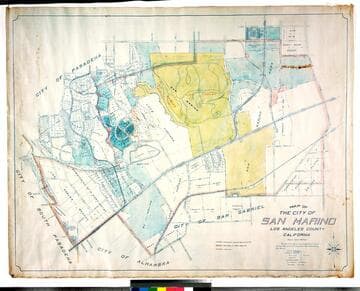
Map of the city of San Marino, Los Angeles County, California
Rare Books
"Scale 1 inch = 300 feet." "The City of San Marino was incorporated as a City of Sixth Class on the 25th day of April 1913 ..." Prime meridian: GM. Relief: no. Graphic Scale: Feet. Projection: Cylindrical. Printing Process: Blue line print. Verso Text: MS notes: City of San Marino Los Robles Ranch colored.
477773