Rare Books
Insula Malta accuratißime Delineata Urbibus et Fortalitiis expressa, a Frederico de Wit, Amstelodami
You might also be interested in

La Guadeloupe Dediée a Mr. Charles Philippe d'Albert Duc de Luynes, Pair de France Chevalier Commander des Ordres du Roy, Seigneur Usufruitier,du Duché de Chevreuse, des Comtés de Montfort, Prevoté, et Seigneurie d'Houdan y réunis, Marquis de Dangeau Baron de St. Hermine et autres Lieux. Par son trés humble et trés Obeissant Serviteur Le Rouge Ingr. Géographe du Roy
Visual Materials
RLIN record provides appeared in information. Cartouche: Flowered frame with crowned standing lion. Submap: l'Isle de Bourbon ou Mascareigne.. Relief: pictorial & hachures. Graphic Scale: Leagues. Projection: Plane. Printing Process: Copper engraving. Other Features: CartoucheSub-maps. Verso Text: MS note: 773.
093:773 M
Image not available
Nova orbis tabula : in lucem edita / A. F. de Wit
Rare Books
Kashnor notes, "Shows California as an island, with the coast continued to the supposed Strait of Anian in the 59th latitude." Kashnor dates as ca. 1688, and from Amsterdam. Shirley indicates first date is 1670, a second plate was created in 1680 with Nova Guinea and Quiri Regio in the left hemisphere. See Shirley, map 451. Decorative map surround. Art work: Scenes of the four seasons with corresponding astrological symbols in all four corners. Submaps: North and South Polar views. Prime meridian: Ferro. Relief: no. Projection: Dual Hemisphere. Watermark: Px. Printing Process: Copper engraving. Verso Text: MS notes: 54/93 148962.
148972
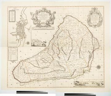
New and Exact Map of the Island of Barbadoes in America, According to an Actual and Accurate Survey made by William Mayo
Visual Materials
Kashnor notes, "Dedicated to James Bridges, Duke of Chandos. With inset plan of Bridgetown, prospect of Codrington College, and engraving representing the making of the survey; also statistics of population." See also 093:745M, another copy as engraved by John Senex 1722. Two elaborate cartouches. Submap - A Plan of Bridgetown. A view of Codrington College. View of surveyor with plane table, and native assistants with measuring wheel, surveying pole and chain. . Prime meridian: London. Relief: pictorial. Graphic Scale: Miles. Projection: Plane. Watermark: JW Whatman 1794. Printing Process: Copper engraving. Other Features: CartoucheSub-mapsVignettes. Verso Text: Ms notes: 174 4 sheets 23, 24, 25, 26..
105:174 M

Plan de la Baye et Rade du Cap Francais dessiné Par M. de Foligne Lieutenant de Fregate du Roi
Visual Materials
Kashnor notes, "A rare map, giving a map of the town and all the old forts to the Cape." Kashnor dates as ca. 1760, submap shows 1780. Sub-map: Carte de St. Domingue 1780. Relief: hachures. Graphic Scale: Miles. Projection: Plane. Watermark: Chained Maltese cross lettering. Printing Process: Copper engraving. Other Features: Sub-maps. Verso Text: MS note: 422.
105:422 M
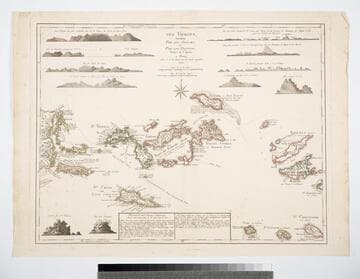
Les Vierges, Levées Par les Anglais, et Par les Dannois, Traduit de l'Anglais
Visual Materials
Description of the islands identifies Jefferys as cartographer. Views: (10) views of various islands. Table: Division des Isles Vierges... detailing ownership of the various islands, English, Danish, and Spanish claims.. Prime meridian: London, Ferro. Relief: hachures. Graphic Scale: Miles. Projection: Plane. Watermark: Chaqined maltese cross lettering. Printing Process: Copper engraving. Other Features: Art Work. Verso Text: MS note: 832.
105:832 M

Carte Réduite de l'Isle de la Martinique Dresée au Dépost des Cartes et Journaux de la Marine
Visual Materials
Cartouche: flower draped. Submap: Plan du Cul de Sac Royal de la Martinique.. "No. 79 (upper right)" "Pour le Service des Vaisseaux du Roy. Par ordre de M. de Moras Ministre et Secretaire d'Etat ayant le Département de la Marine. Par M. Bellin Ingénieur de la Marine et du Dépost des Plans, Censeur Royal, de l'Academie de Marine, et las Société Royale de Londres. M DCC LVIII (1758)." Relief: pictorial. Graphic Scale: Leagues. Projection: Plane. Watermark: Seal & Lettering. Printing Process: Copper engraving. Other Features: Sub-mapsCartouche.
105:504 M