Visual Materials
Chart of the Harbour of Halifax, in Nova Scotia; with Jebucto Bay and Cape Sambro also the Islands, Ledges of Rocks, Shoals & Soundings. Survey'd by Order of His Excellency Brigadier General Lawrence, Governour of the Province of Nova Scotia; by Charles Morris, Chief Surveyor, 1759
You might also be interested in
Image not available
A Chart of the Harbour of Halifax, in Nova Scotia; with Jebucto Bay and Cape Sambro. also the Islands, Ledges of Rocks, Shoals & Soundings
Visual Materials
Kashnor notes, "The first issue of the Morris chart. It is the first separate chart of Halifax Harbour." The publication date is 1775 but Kashnor dates the map at [1760]. Includes sailing directions. Kershaw gives appeared in information and notes this is the second state of Jefferys' map. Detailed sailing directions.. "Survey'd by Order of His Excellency Brigadier General Lawrence, Governour of the Province of Nova Scotia; By Charles Morris, Chief Surveyor, Published by Command of the Rgiht Honourable the Lords of Trade & Plantations, For the Benefit of the Trade and Navigation of Great Britain and its Colonies." "To the Right Honourable George Dunk Earl of Halifax, First Lord Commissioner, and to the rest of the Right Honourable and Honourable Commissioners for Trade and Plantations, This Chart is most humbly Inscribed By their most obliged & obedient humble Sert. Thos. Jefferys." "London Engraved by Thomas Jefferys, Geographer to the King." Relief: hachures. Graphic Scale: Miles. Projection: Plane. Watermark: Crowned fluer-di-lis VI. Printing Process: Copper engraving. References: Kershaw 821. Verso Text: Ms note: 20.
105:660 M
Image not available
New Map of Nova Scotia, and Cape Breton Island with the adjacent parts of New England and Canada, Composed from a great number of actual Surveys; and other material Regulated by many new Astronomical Observations of the Longitude as well as Latitude; by Thomas Jefferys, Geographer to the King
Visual Materials
See map 093:270M for later edition. RLIN record provides appeared in information. Kershaw identifies this as the fourth state of Jefferys' map. Prime meridian: Ferro. Relief: pictorial. Projection: Conic. Watermark: Crowned fleur-di-lis VI. Printing Process: Copper engraving. Other Features: Cartouche. References: Kershaw 745; LC Phillips 1166,1208. Verso Text: MS note: 269.
093:269 M
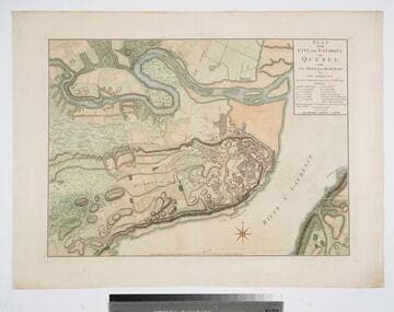
Plan of the City and Environs of Quebec with its Siege and Blockade by the Americans, from the 8th of December 1775 to the 13th of May 1776
Visual Materials
Kashnor notes, "A very fine war plan, in colours, showing where Montgomery made his attack and the emplacement of batteries." A stunning map. Kershaw supplies appeared in information. Relief: hachures. Graphic Scale: Yards. Projection: Plane. Watermark: Crowned fluer-di-lis W F. Printing Process: Copper engraving. References: Kershaw 1041; LC Phillips 1207,1337.. Verso Text: MS note: 120.
093:120 M
Image not available
Gut of Canso, which divides the Island of Cape Breton from the Continent of Nova Scotia
Visual Materials
Kashnor notes, " A long chart with sailing directions, very rare." Text with sailing directions.. Prime meridian: GM. Relief: pictorial. Graphic Scale: Miles, statute & nautical. Projection: Cylindrical. Watermark: Crowned fleur-di-lis. Printing Process: Copper engraving. Verso Text: MS note: 117.
093:117 M

New Map of the Island of Tobago shewing all the Rocks Shoals and Soundings Engraved from an Actual Survey By Thos. Kitvhin, Hydrographer to His Majesty
Visual Materials
Kashnor dates as [1770]. Cartouche: neptune w. flowering bows.. Relief: no. Graphic Scale: Leagues. Projection: Cylindrical. Watermark: Crowned fluer-di-lis IV. Printing Process: Copper engraving. Other Features: Cartouche. Verso Text: MS notes: 838 50.
093:838 M
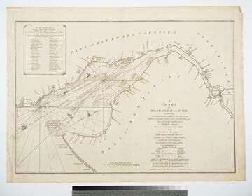
A Chart of Delaware Bay and River, containing A full and exact Description of the Shores, Creeks, Harbours, Soundings, Shoals, Sands, and Bearings of the most considerable Land Marks &c. &c. Faithfully coppied (sic) From that Published at Philadelphia By Joshua Fisher, Together with the Tide Table from the Capes to Philadelphia, and the Set of the Tide on the Several Quarters of the Flood and Ebb
Visual Materials
Contains table of subscribers for this chart. Table of subscribers for this chart.. Relief: no. Graphic Scale: Miles. Projection: Plane. Watermark: Crowned fluer-di-lis VI. Verso Text: MS note: 388 4.
105:388 M