Visual Materials
A Chart of Delaware Bay and River, containing A full and exact Description of the Shores, Creeks, Harbours, Soundings, Shoals, Sands, and Bearings of the most considerable Land Marks &c. &c. Faithfully coppied (sic) From that Published at Philadelphia By Joshua Fisher, Together with the Tide Table from the Capes to Philadelphia, and the Set of the Tide on the Several Quarters of the Flood and Ebb

You might also be interested in

The Coast of West Florida and Louisiana by Thos. Jefferys, Geographer to His Majesty.: Peninsula and Gulf of Florida or Channel of Bahama with Bahama Islands, by Thos. Jefferys, Geographer to His Majesty
Visual Materials
Two maps spliced to form one map. See 105:393 for a later version of this map. Prime meridian: London. Relief: pictorial. Projection: Cylindrical. Watermark: Crowned fluer-di-lis VI. Printing Process: Copper engraving. Verso Text: MS notes: 392 32.
105:392 M

The Coast of West Florida and Louisiana by Thos. Jefferys, Geographer to His Majesty.: Peninsula and Gulf of Florida or Channel of Bahama with Bahama Islands, by Thos. Jefferys, Geographer to His Masjesty
Visual Materials
Two maps spliced to form one map. See 105:392 for a later version. See 105:393-Dup. for another copy. Prime meridian: London. Relief: pictorial. Projection: Cylindrical. Watermark: Crowned fluer-di-lis VI. Printing Process: Copper engraving. Verso Text: MS notes: 393.
105:393 M

Accurate Map of North and South Carolina with their Indian Frontiers, showing in a distinct manner all the Mountains, Rivers, Swamps, Marshes, Bays, Creeks, Harbours, Sandbanks and Soundings on the Coast, with the Roads and Indian Paths as well as the Boundary or Provincial Lines, the Several Townships and other divisions of the Land in Both the Provinces; the whole from Actual Surveys by Henry Mouzon and others
Visual Materials
Noted as duplicate of 192531, 29-30 and 2813, #73-74. Submap: Harbour at Port Royal; Bar and Harbour of Charlestown.. Prime meridian: London. Relief: hachures. Projection: Cylindrical. Watermark: Crowned fluer-di-lis VI. Printing Process: Copper engraving. Other Features: Sub-maps. Verso Text: MS note: 73 H. E. H. Dupl. stamp..
105:073 M
Image not available
A Chart of the Harbour of Halifax, in Nova Scotia; with Jebucto Bay and Cape Sambro. also the Islands, Ledges of Rocks, Shoals & Soundings
Visual Materials
Kashnor notes, "The first issue of the Morris chart. It is the first separate chart of Halifax Harbour." The publication date is 1775 but Kashnor dates the map at [1760]. Includes sailing directions. Kershaw gives appeared in information and notes this is the second state of Jefferys' map. Detailed sailing directions.. "Survey'd by Order of His Excellency Brigadier General Lawrence, Governour of the Province of Nova Scotia; By Charles Morris, Chief Surveyor, Published by Command of the Rgiht Honourable the Lords of Trade & Plantations, For the Benefit of the Trade and Navigation of Great Britain and its Colonies." "To the Right Honourable George Dunk Earl of Halifax, First Lord Commissioner, and to the rest of the Right Honourable and Honourable Commissioners for Trade and Plantations, This Chart is most humbly Inscribed By their most obliged & obedient humble Sert. Thos. Jefferys." "London Engraved by Thomas Jefferys, Geographer to the King." Relief: hachures. Graphic Scale: Miles. Projection: Plane. Watermark: Crowned fluer-di-lis VI. Printing Process: Copper engraving. References: Kershaw 821. Verso Text: Ms note: 20.
105:660 M
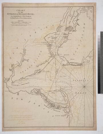
Chart of the Entrance of Hudson's River, from Sandy Hook to New York, with the Banks, Depths of Water, Sailing-marks &ca
Visual Materials
Kashnor notes, " The first issue of this chart. It was reissued in 1800 by Laurie & Whittle, but without date." Relief: hachures. Graphic Scale: Miles. Projection: Plane. Watermark: Crowned fleur-di-lis VI. Printing Process: Copper engraving. Verso Text: MS notes: 3 578.
105:578 M

Coast of West Florida and Louisiana by Thos. Jefferys, Geographer to His Majesty.: Peninsula and Gulf of Florida or Channel of Bahama with Bahama Islands, by Thos. Jefferys, Geographer to His Masjesty
Visual Materials
Two maps spliced to form one map. See 105:392 for an earlier version. Prime meridian: London. Relief: pictorial. Projection: Cylindrical. Watermark: Crowned fluer-di-lis VI. Printing Process: Copper engraving. Verso Text: MS notes: 740 25.
093:740 M