Rare Books
Gray's New Map of Virginia / by Frank A. Gray
You might also be interested in
Image not available
Gray's New Map of Virginia
Rare Books
Detailed county map of the State. Submaps: United States; Western Virginia. "By Frank A. Gray prepared for the Department of Agriculture of Virginia Dr. Thomas Pollard Commissioner and the Bureau of Immigration of Virginia Capt. Richard Irby General Agent. by O. W. Gray & Son, Philadelphia. 56 North Fourth Street. Entered according to Act of Congress in the year 1879 by O. W. Gray & Son in the Office of the Librarian of Congress at Washington." Prime meridian: GM, Washington. Relief: hachures. Graphic Scale: Miles. Projection: Cylindrical. Printing Process: Lithography. Other Features: Sub-maps. Verso Text: HL sticker: 128314.
128314
Image not available
Map of South America
Rare Books
"Prepared especially for The National Geographic Magazine Gilbert Grosvenor, Editor." Submaps: Physical Map of South America; Mean annual temperature; Economic Map of South America. Prime meridian: GM. Relief: shaded. Graphic Scale: Miles, kilometers. Projection: Polyconic. Printing Process: Lithography.
235652
Image not available
[Outline map of United States]
Rare Books
Vanilla outline map. "Department of the Interior Harold L. Ickes, Secretary General Land Office, Fred W. Johnson, Commissioner." Prime meridian: GM. Relief: no. Graphic Scale: Miles. Projection: Polyconic. Printing Process: Lithography. Verso Text: MS note: 32719.
266836
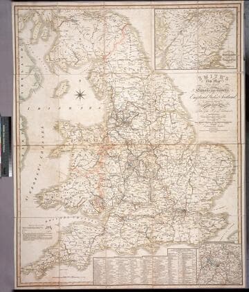
Smith's new map of the navigable canals and ri vers, of England, Wales & Scotland : distinctly shewing the length of each line, and the dates of the Acts of Parliament which have passed for executing the same ; containing also the direct roads to the principal places, with their distance from London
Rare Books
Alternate title from cover. A detailed map of the extensive network of canals and rivers crossing the UK in early 1800's. Submaps: Canals in the Environs of Birmingham; Continuation of Scotland including the Caledonian Canal. Table of principal canals with lengths. Prime meridian: GM. Relief: no. Graphic Scale: Miles. Projection: Polyconic. Printing Process: Engraving.
446560
Image not available
Map of Virginia
Rare Books
First of a series of maps of Virginia showing various details. This map shows railways and canals. Note that each of these three maps is at a slightly different scale. Excerpted from: Virginia. Immigration Baord. Virginia: A Geographical and Political Summary, ...Richmond, 1876. "by Jed. Hotchkiss, Top. Eng. Staunton, Va. 1874" "No. 1 (upper right). Copyright 1875 by Jed Hotchkiss." Prime meridian: GM. Relief: hachures. Graphic Scale: Miles. Projection: Polyconic. Printing Process: Lithography. Verso Text: HL sticker: 128064.
128064
Image not available
Map of Virginia.; Natural Divisions of Virginia
Rare Books
Second of a series of maps of Virginia showing various details. This map shows natural divisions. Note that each of these three maps is at a slightly different scale. Excerpted from: Virginia. Immigration Baord. Virginia: A Geographical and Political Summary, ...Richmond, 1876. "By Jed. Hotchkiss, Top. Eng. Staunton, Va. 1874." "No. 2 (upper right). Copyright 1875 by Jed Hotchkiss." Prime meridian: GM. Relief: no. Graphic Scale: Miles. Projection: Polyconic. Printing Process: Lithography. Verso Text: HL sticker: 128066.
128066