Rare Books
Gray's New Map of Virginia
You might also be interested in
Image not available
Gray's New Map of Virginia / by Frank A. Gray
Rare Books
"Prepared for the Railroad Commissioner of Virginia, Col. George A. Martin, Commissioner." Submaps: Outline Map of the United States; South western Virginia; Environs of Harper's Ferry; Norfolk Harbor. Prime meridian: GM, Washington. Relief: hachures. Graphic Scale: Miles. Projection: Polyconic. Printing Process: Lithography.
258259
Image not available
Map of Virginia
Rare Books
First of a series of maps of Virginia showing various details. This map shows railways and canals. Note that each of these three maps is at a slightly different scale. Excerpted from: Virginia. Immigration Baord. Virginia: A Geographical and Political Summary, ...Richmond, 1876. "by Jed. Hotchkiss, Top. Eng. Staunton, Va. 1874" "No. 1 (upper right). Copyright 1875 by Jed Hotchkiss." Prime meridian: GM. Relief: hachures. Graphic Scale: Miles. Projection: Polyconic. Printing Process: Lithography. Verso Text: HL sticker: 128064.
128064
Image not available
Map of Virginia
Rare Books
Third of a series of maps of Virginia showing various details. This map shows geology with emphasis on coal bearing stratas. Note that each of these three maps is at a slightly different scale. Excerpted from: Virginia. Immigration Baord. Virginia: A Geographical and Political Summary, ...Richmond, 1876. "By Jed. Hotchkiss, Top. Eng. Staunton, Va. 1874." "The Geology by Prof. William B. Rogers Chiefly from the State Survey 1835-'41. "With later observations in some parts." "Copyright 1875 by Jed Hotchkiss." Prime meridian: GM. Relief: no. Graphic Scale: Miles. Projection: Polyconic. Printing Process: Lithography. Verso Text: HL sticker: 128065.
128065
Image not available
Map of Virginia.; Natural Divisions of Virginia
Rare Books
Second of a series of maps of Virginia showing various details. This map shows natural divisions. Note that each of these three maps is at a slightly different scale. Excerpted from: Virginia. Immigration Baord. Virginia: A Geographical and Political Summary, ...Richmond, 1876. "By Jed. Hotchkiss, Top. Eng. Staunton, Va. 1874." "No. 2 (upper right). Copyright 1875 by Jed Hotchkiss." Prime meridian: GM. Relief: no. Graphic Scale: Miles. Projection: Polyconic. Printing Process: Lithography. Verso Text: HL sticker: 128066.
128066
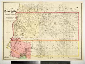
Sectional and Topographical Map of Colfax and Mora Counties Territory of New Mexico
Rare Books
Numerous changes have been made since the earlier map, 128069. "Compiled from the Original Plats in the Surveyor Generals Office Santa Fe, New Mexico. J. S. Taylor U. S. Deputy Surveyor, 1881." "Entered according to Act of Congress in the year 1882 by G.W. & C.B. Colton & Co. in the Office of the Librarian of Congress, at Washington." Prime meridian: GM. Relief: hachures. Graphic Scale: Miles. Projection: Cylindrical. Printing Process: Lithography. Verso Text: HL sticker: 128313.
128313
Image not available
Map of the New York Wilderness and the Adirondacks
Rare Books
"By W. W. Ely, M.D. 1874" "Entered according to Act of Congress in the year 1873 by G.W. & C.B. Colton in the Office of the Librarian of Congress at Washington." Submap: New England and Eastern US.. Prime meridian: Washington. Relief: hachures. Graphic Scale: Miles. Projection: Cylindrical. Printing Process: Lithography. Other Features: Sub-maps.
123304