Rare Books
Smith's new map of the navigable canals and ri vers, of England, Wales & Scotland : distinctly shewing the length of each line, and the dates of the Acts of Parliament which have passed for executing the same ; containing also the direct roads to the principal places, with their distance from London

You might also be interested in
Image not available
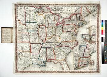
A new map for travelers through the United States of America : showing the railroads, canals and stage roads with the distances / by J. Calvin Smith
Rare Books
Alternate title from cover. Gift of Mr. & Mrs. Robert P. Hastings September 1975. Submaps: Map of Oregon Northern California Santa Fe &c.; Map showing the Rail Roads between the Cities of New York, Boston & Albany, and the Hudson R. from New York to Albany; Railroad Route from New York to Philadelphia; Railroad and Canal routes from Albany to Buffalo. Prime meridian: Washington. Relief: no. Graphic Scale: Miles. Projection: Polyconic. Printing Process: Lithography.
442530
Image not available
Geographical and physical map of the world : on Mercator's Projection shewing the British possessions with the date of their accession, population, &c all the existing steam navigation, the overland route to India, with the proposed extension to Australia, also the route to Australia via Panama / by Smith Evans
Rare Books
First alternate title at head of map; second alternate title from cover. Includes a claim to South Victoria based on 1841 Ross Expedition. Lots of detail on potential emigration to various sites including California and Texas. Submaps: Mountain and Rivers of the World. Prime meridian: GM. Relief: hachures. Projection: Mercator. Printing Process: Lithography. Verso Text: MS notes: Evans, Henry Smith 98463.
98463
Colton's map of the United States, the Canadas &c showing the rail roads, canals & stage roads with distances from place to place
Rare Books
Kirkpatrick Catalogue entry: "2463 Colton, J. H., publisher. Colton's map of the United States, the Canadas &c. showing the rail roads, canals, & stage roads ... New York, J. H. Colton, 1860. 1 sheet. [see p.]."Alternate title from cover. Submaps: Map of New England and Eastern New York; Map of the United States & Central America; The Isthmus of Panama showing the Routes of Travel between Aspinwall & Panama. . Prime meridian: GM, Washington. Relief: hachures. Graphic Scale: Miles. Projection: Polyconic. Printing Process: Lithography. Other Features: Sub-maps. Verso Text: MS note: R.B. 11486, i Stamp: Kensington Public Libraries.
623637