Rare Books
Colton's Map of the States of New England and New York, with parts of Pennsylvania, New Jersey, The Canadas &c. showing the railroads, canals and stage roads, with distances from place to place / Drawn by George W. Colton
You might also be interested in
Image not available
A new map for travelers through the United States of America : showing the railroads, canals and stage roads with the distances / by J. Calvin Smith
Rare Books
Alternate title from cover. Gift of Mr. & Mrs. Robert P. Hastings September 1975. Submaps: Map of Oregon Northern California Santa Fe &c.; Map showing the Rail Roads between the Cities of New York, Boston & Albany, and the Hudson R. from New York to Albany; Railroad Route from New York to Philadelphia; Railroad and Canal routes from Albany to Buffalo. Prime meridian: Washington. Relief: no. Graphic Scale: Miles. Projection: Polyconic. Printing Process: Lithography.
442530
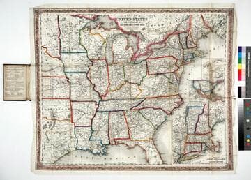
Colton's map of the United States, the Canadas &c showing the rail roads, canals & stage roads with distances from place to place
Rare Books
Kirkpatrick Catalogue entry: "2463 Colton, J. H., publisher. Colton's map of the United States, the Canadas &c. showing the rail roads, canals, & stage roads ... New York, J. H. Colton, 1860. 1 sheet. [see p.]."Alternate title from cover. Submaps: Map of New England and Eastern New York; Map of the United States & Central America; The Isthmus of Panama showing the Routes of Travel between Aspinwall & Panama. . Prime meridian: GM, Washington. Relief: hachures. Graphic Scale: Miles. Projection: Polyconic. Printing Process: Lithography. Other Features: Sub-maps. Verso Text: MS note: R.B. 11486, i Stamp: Kensington Public Libraries.
623637
Image not available
Map of the State of New York : Showing the boundaries of counties, townships, the location of cities, towns and villages; the courses of the Rail Roads, Canals, Stage Roads / by J. Calvin Smith
Rare Books
Submaps: City of New York with parts of Brooklyn and Williamsburgh; The St. Lawrence River from the New York State Line to Quebec. Prime meridian: GM, Washington. Relief: hachures. Graphic Scale: Miles. Projection: Cylindrical. Printing Process: Steel engraving.
336019
Image not available
Watson's new rail-road and distance map of the United States and Canada
Rare Books
Alternate title from cover. Submaps: Vicinity of New York; Vicinity of Boston; Vicinity of Philadelphia; Routes of the Union Pacific Railroads. Cartouche: Locomotive San Francisco. Prime meridian: GM, Washington. Relief: hachures. Graphic Scale: Miles. Projection: Polyconic. Printing Process: Lithography.
423876
Image not available
Mitchell's Travellers Guide through the United States. A Map of the Roads, Distances, Steamboat & Canal Routes &c. / by J. H. Young Philadelphia
Rare Books
Cover includes travelers guide of cities and distances, along with steamship routes. For earlier editions, see RB 82384, & 82385; for later editions see 442783 & 429902. Gift of Max Farrand 1936. Submaps: Vicinity of Boston; Vicinity of New York; Vicinity of Philadelphia; Vicinity of Baltimore and Washington; Vicinity of Charleston; Vicinity of Cincinnati; Vicinity of Albany; Vicinity of the Falls of Niagara. Prime meridian: Washington. Relief: no. Graphic Scale: Miles. Projection: Polyconic. Printing Process: Steel engraving.
224605
Image not available
Mitchell's new traveller's guide through the United States : showing the rail roads, canals, stage roads &c. with distances from place to place / drawn and engraved by Ira S. Drake
Rare Books
For earlier editions of this map, see 224605, 82384, 82385, & 429902. Submaps: Map of the Copper Mine Region; Map of New England or Eastern States; Map of Gold and Quicksilver District of California; Map of Maritime and Overland Routes to California. Prime meridian: Washington. Relief: no. Graphic Scale: Miles. Projection: Polyconic. Printing Process: Lithography. Verso Text: MS note: Mr. Charles E. Tufts Book, presented to him by Robert H. Anderson, in the year of one thousand eight hundred and sixty at Cedar Point in Googhland County - Virginia.
442783