Rare Books
Map of the State of New York : Showing the boundaries of counties, townships, the location of cities, towns and villages; the courses of the Rail Roads, Canals, Stage Roads / by J. Calvin Smith
You might also be interested in
Image not available
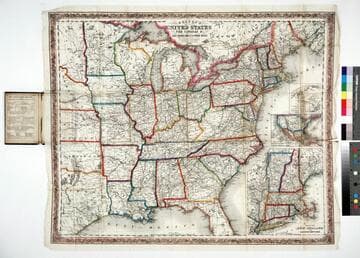
A new map for travelers through the United States of America : showing the railroads, canals and stage roads with the distances / by J. Calvin Smith
Rare Books
Alternate title from cover. Gift of Mr. & Mrs. Robert P. Hastings September 1975. Submaps: Map of Oregon Northern California Santa Fe &c.; Map showing the Rail Roads between the Cities of New York, Boston & Albany, and the Hudson R. from New York to Albany; Railroad Route from New York to Philadelphia; Railroad and Canal routes from Albany to Buffalo. Prime meridian: Washington. Relief: no. Graphic Scale: Miles. Projection: Polyconic. Printing Process: Lithography.
442530
Colton's map of the United States, the Canadas &c showing the rail roads, canals & stage roads with distances from place to place
Rare Books
Kirkpatrick Catalogue entry: "2463 Colton, J. H., publisher. Colton's map of the United States, the Canadas &c. showing the rail roads, canals, & stage roads ... New York, J. H. Colton, 1860. 1 sheet. [see p.]."Alternate title from cover. Submaps: Map of New England and Eastern New York; Map of the United States & Central America; The Isthmus of Panama showing the Routes of Travel between Aspinwall & Panama. . Prime meridian: GM, Washington. Relief: hachures. Graphic Scale: Miles. Projection: Polyconic. Printing Process: Lithography. Other Features: Sub-maps. Verso Text: MS note: R.B. 11486, i Stamp: Kensington Public Libraries.
623637
Image not available
Phelps & Ensign's travellers' guide and map of the United States, containing the roads, distances, steam boat and canal routes, &c
Rare Books
Alt. title from cover. Submaps: Vicinity of Niagara Falls; North Maine; New York; Philadelphia; Boston; Baltimore; New Orleans; Mobile; Cincinnati; St. Louis; Charleston; Pittsburg(h); Chicago; Detroit; Washington; South Florida. Prime meridian: Washington. Relief: hachures. Graphic Scale: Miles. Projection: Polyconic. Printing Process: Steel engraving.
358822
Image not available
Watson's new rail-road and distance map of the United States and Canada
Rare Books
Alternate title from cover. Submaps: Vicinity of New York; Vicinity of Boston; Vicinity of Philadelphia; Routes of the Union Pacific Railroads. Cartouche: Locomotive San Francisco. Prime meridian: GM, Washington. Relief: hachures. Graphic Scale: Miles. Projection: Polyconic. Printing Process: Lithography.
423876
Image not available
Cary's new map of Ireland : exhibiting the whole of the turnpike roads with the rivers and canals ; the market and borough towns and principal places adjoining the road to which is added the distances from one market town to another as well as from the metropolis
Rare Books
Alte title from cover; sales sticker on cover reads: "Sold by C. Smith. Mapseller, 172 Strand, London." Prime meridian: GM. Relief: hachures. Graphic Scale: Miles. Projection: Cylindrical. Printing Process: Copper engraving.
386441
Image not available
Colton's Map of the States of New England and New York, with parts of Pennsylvania, New Jersey, The Canadas &c. showing the railroads, canals and stage roads, with distances from place to place / Drawn by George W. Colton
Rare Books
Bound into Guide book with smaller map of the middle states facing title page. Gift of Max Farrand. Submaps: Plan of the City of Boston; Plan of the City of New York; The Rail Road routes between Philadelphia, New York and Baltimore and Washington. Vignettes: Boston; New York; Montreal; Toronto. Prime meridian: Washington. Relief: hachures. Graphic Scale: Miles. Projection: Polyconic. Printing Process: Lithography.
224607