Rare Books
Watson's new rail-road and distance map of the United States and Canada
You might also be interested in
Image not available
Watson's New County & Rail Road Map of the Pacific States
Rare Books
Vignette: State Capitol. Prime meridian: GM, Washington. Relief: hachures. Graphic Scale: Miles. Projection: Polyconic. Printing Process: Lithography.
264606
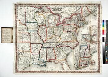
Colton's map of the United States, the Canadas &c showing the rail roads, canals & stage roads with distances from place to place
Rare Books
Kirkpatrick Catalogue entry: "2463 Colton, J. H., publisher. Colton's map of the United States, the Canadas &c. showing the rail roads, canals, & stage roads ... New York, J. H. Colton, 1860. 1 sheet. [see p.]."Alternate title from cover. Submaps: Map of New England and Eastern New York; Map of the United States & Central America; The Isthmus of Panama showing the Routes of Travel between Aspinwall & Panama. . Prime meridian: GM, Washington. Relief: hachures. Graphic Scale: Miles. Projection: Polyconic. Printing Process: Lithography. Other Features: Sub-maps. Verso Text: MS note: R.B. 11486, i Stamp: Kensington Public Libraries.
623637
Image not available
Watson's new county and railroad map of the western states and territories
Rare Books
Alt. title from cover. Gift of the Friends of the Huntington Library. Streeter VI #3936. Prime meridian: GM, Washington. Relief: hachures. Graphic Scale: Miles. Projection: Polyconic. Printing Process: Lithography.
405353
Image not available
Colton's new rail road & county map of the United States, the Canadas &c
Rare Books
Alt. title from cover. Submaps: Southern Part of Florida; Map of the United States. Prime meridian: Washington. Relief: hachures. Graphic Scale: Miles. Projection: Polyconic. Printing Process: Lithography.
353762
Image not available
Colton's New Railroad & County Map of the United States The Canadas &c
Rare Books
Alt. title on cover. Submaps: Southern End of Florida; Colton's Map of the United States showing the Proposed Railroad Routes to the Pacific Ocean. Prime meridian: GM, Washington. Relief: hachures. Graphic Scale: Miles. Projection: Polyconic. Printing Process: Lithography.
254732

Watson's new map of the western states, territories, Mexico, and Central America
Rare Books
Alt title is from the cover. Shows numerous "proposed railroads." MS note: 29 by 38 Submap; Central America. Table: Distances of rivers. Prime meridian: GM, Washington. Relief: hachures. Graphic Scale: Miles. Projection: Polyconic. Printing Process: Lithography.
289838