Rare Books
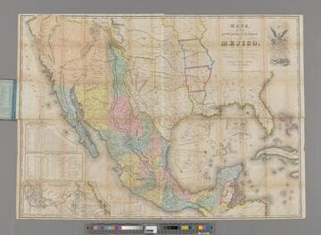
Mapa de los Estados de Méjico
- Description
- Kashnor notes, "An important map of California, Texas, and the Western Territories, then included in Mexico, which extended from the southern frontiers of Arkansas and Oregon to the northern boundary of Guatemala." Cartouche: Mexican Eagle. Submap: Roads between Vera Cruz and Mexico City. Tables of distance and population of various states. "M-- 21st, 1828 (bottom neatline)" "Legunlo organizado y definido per las varias actas del Congreso de dicha Republica y construido por las mejores authoridadtes." Prime meridian: Washington. Relief: hachures. Graphic Scale: Miles. Projection: Pseudocylindrical. Printing Process: Lithography. Other Features: CartoucheSub-maps. Verso Text: MS notes: 234/105 Mexico XI J. 19 148960.
- Date
- 21 March 1828
- Call number
- 148960
- Dimensions
- 74 x 104 cm
- Associated organization
- Balch, Stiles, Wright & Co. (Engravers : New York)