Rare Books
A New Map of the United States. Upon which are delineated its vast works of Internal communication, Routes across the Continent &c.; Showing also Canada and the Island of Cuba
You might also be interested in
Image not available
A new map of the United States : upon which are delineated it's vast works of internal communication, routes across the continent, &c., showing also Canada and the Island of Cuba / by W. Williams
Rare Books
Alt. title from cover. Submaps: Map of California, Oregon, New Mexico, Utah, &c.; Island of Cuba; Harbor of Havana; Niagara River & Falls. Prime meridian: GM, Washington. Relief: hachures. Graphic Scale: Miles. Projection: Polyconic. Printing Process: Lithography.
353748
Image not available
Map of Mexico, including Yucatan & Upper California, exhibiting the Chief Cities and Towns, the Principal Travelling Routes &c
Rare Books
Inset map of "The Late Battlefield." Sub map: The Late Battlefield [Monterey] "Enetered according to the Act of Congress in the year 1846 by S. Augustus Mitchell, in the Clerk's office of the District Court of the Eastern District of Pennsylvania." MS notes: 189 20240 . Prime meridian: GM, Washington. Relief: no. Graphic Scale: Miles. Projection: Pseudocylindrical. Printing Process: Lithography. Other Features: Sub-maps.
20240
Image not available
New York; Philadelphia; Baltimore; Boston
Rare Books
A four part map of the heart of these four cities, rail lines shown in red. "Entered accoridng to Act of Congress in the year 1850 by J. Disturnell in the Clerk's Office of the District Court of the Southern District of N. Y." Relief: no. Graphic Scale: Feet. Projection: Plane. Printing Process: Lithography. Verso Text: HL sticker: 127980.
127980
Image not available
The Districts of Quebec, Three Rivers, St. Francis and Gaspe, Lower Canada
Rare Books
A very large linen backed map. Includes sea view vignettes and a sub map of the tip of the Gaspe peninsula. The border with Maine is not clearly defined. Sub map: Map of the Interior District of Gaspe. Vignettes: Five sea views of shore. "To His most Excellent Majesty William IV. This Topographical Map of... exhibiting the New Civil Division of the Districts into Counties pursuant to a recent Act of the Provincial Legislature; With His Majesty's gracious and special permission Most humbly and gratefully Dedicated by His Majesty's most loyal and devoted Canadian subject, Joseph Bouchette, His Majesty's Surveyor General of the Province and and Lieut' Colonel C. M." "Engraved by J. & C. Walker 47 Bernard Street, Rafael Square." Prime meridian: GM . Relief: hachures. Graphic Scale: Miles, leagues. Projection: Cylindrical. Printing Process: Copper engraving. Other Features: Vignettes Sub-maps. Verso Text: HL Sticker: 127671.
127671
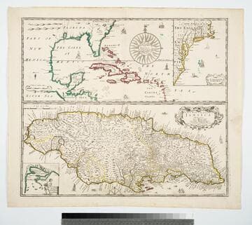
General Mapp of the Continent and Islands which bee adjacent to Jamaica
Visual Materials
Kashnor notes, "Shows Carolina on the large map, and New England, Virginia and Carolina on the smaller map of the English Empire." This is four maps in one. The map of Jamaica is larger than the principal map. Two smaller maps show the English Empire, and a New Draught of Port Royal by Anthony Williams. Four maps on one sheet.. Prime meridian: London. Relief: pictorial. Graphic Scale: Miles. Projection: Mercator. Printing Process: Copper engraving. Other Features: Sub-maps. Verso Text: MS note: 322 SI.
105:322 M
Image not available
A New Map of the Gold Region in California
Rare Books
Accompanied by a written description of California. Note that turning point is shown to the west of Mountain Lake (Lake Tahoe) which would have been easier to survey than the actual turning point. "By Charles Drayton Gibbes. From his own and other Recent Surveys & Explorations 1851." "Entered according to Act of Congress in the year 1851 by Sherman & Smith in the Clerk's office of the District Court for the Southern District of New York." Cover title: Accompaniment to Gibbes' New Map of the Gold Region in California. Ms note: 131781. Prime meridian: GM. Relief: hachures. Graphic Scale: Miles. Projection: Polyconic. Printing Process: Lithography.
131781