Rare Books
New York; Philadelphia; Baltimore; Boston
You might also be interested in
Image not available
A New Map of the United States. Upon which are delineated its vast works of Internal communication, Routes across the Continent &c.; Showing also Canada and the Island of Cuba
Rare Books
Rail lines end at Jefferson City, MO and Memphis, TN with proposed extensions shown. Western US shown on sub map. Sub maps: Map of the Island of Cuba; City & Harbor of Havana; Map of Niagra River and Falls; Map of California, Oregon, New Mexico, Utah, &c. "By W. Williams, Philadelphia." "Entered according to Act of Congress in the year 1855, by W. Williams in the Clerk's Office of the District Court of the Eastern District of Pennsylvania." Prime meridian: GM, Washington. Relief: hachures. Graphic Scale: Miles. Projection: Pseudocylindrical. Printing Process: Lithography. Other Features: Sub-maps. Verso Text: HL sticker: 128059.
128059
Image not available
Map of Baltimore
Rare Books
Street and public area directory in the surround. "Entered according to the Act of Congress, in the year 1867, by John W. Woods, in the Clerk's Office of the District Court of Maryland." "Lith. by A. Hoen & Co. Second St. Balto." Prime meridian: GM. Relief: no. Projection: Plane. Printing Process: Lithography. Verso Text: MS note: 127979.
127979
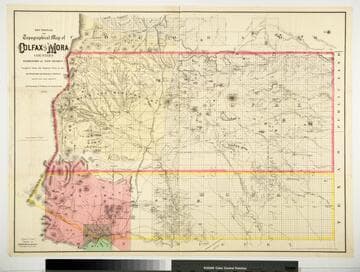
Sectional and Topographical Map of Colfax and Mora Counties Territory of New Mexico
Rare Books
Numerous changes have been made since the earlier map, 128069. "Compiled from the Original Plats in the Surveyor Generals Office Santa Fe, New Mexico. J. S. Taylor U. S. Deputy Surveyor, 1881." "Entered according to Act of Congress in the year 1882 by G.W. & C.B. Colton & Co. in the Office of the Librarian of Congress, at Washington." Prime meridian: GM. Relief: hachures. Graphic Scale: Miles. Projection: Cylindrical. Printing Process: Lithography. Verso Text: HL sticker: 128313.
128313

Hutchings’ California Scenes.-Methods of Mining
Rare Books
Image contains twelve vignettes each depicting different methods of mining. To the right is a list of sixty-four names of mining localities. "Entered according to Act of Congress, in the year 1855, by Jas M. Hutchings, in the Clerk's Office of the U.S. District Court for the Northern District of California. Published by J. M. Hutchings, San Francisco."--text, below image. Paper color: blue.
48052:081
Image not available
Gray's New Map of Virginia
Rare Books
Detailed county map of the State. Submaps: United States; Western Virginia. "By Frank A. Gray prepared for the Department of Agriculture of Virginia Dr. Thomas Pollard Commissioner and the Bureau of Immigration of Virginia Capt. Richard Irby General Agent. by O. W. Gray & Son, Philadelphia. 56 North Fourth Street. Entered according to Act of Congress in the year 1879 by O. W. Gray & Son in the Office of the Librarian of Congress at Washington." Prime meridian: GM, Washington. Relief: hachures. Graphic Scale: Miles. Projection: Cylindrical. Printing Process: Lithography. Other Features: Sub-maps. Verso Text: HL sticker: 128314.
128314
Image not available
Map of the United States, showing by color the Area of Freedom and Slavery, and the Territories whose Destiny is yet to be decided New York
Rare Books
A map with statistics in the surround published just before the Civil War. Vignettes: Portraits of Fremont and Wm. L. Dayton. Statistical tables. "Exhibiting also the Missouri Compromise Line and the routes of Colonel Fremont in his famous explorations, with important statistics of the free and slave States." "Entered according to Act of Congress in the year 1855, by J. H. Colton in the Clerk's office of the District Court for the southern district of New York." Prime meridian: GM, Washington. Relief: hachures. Graphic Scale: Miles. Projection: Polyconic. Printing Process: Lithography. Other Features: Vignettes.
152132