Rare Books
Map of the Field Operations of the Army of Virginia during the Months of July and August 1862
You might also be interested in
Image not available
Map of the Cherokee Outlet Oklahoma Territory
Rare Books
One map in two sheets, not joined, shwoing lands with varying valuations. Set asides and Indian lands are shown. Each section has designated areas for public buildings and schools. "Department of the Interior Hon. Hoke Smith, Secretary" "Showing lands to be opened for settlement on September 16th 1893 under proclamation of the President..." Relief: no. Projection: Plane. Printing Process: Lithography. Verso Text: HL sticker: 17775.
117775
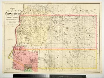
Sectional and Topographical Map of Colfax and Mora Counties Territory of New Mexico
Rare Books
Numerous changes have been made since the earlier map, 128069. "Compiled from the Original Plats in the Surveyor Generals Office Santa Fe, New Mexico. J. S. Taylor U. S. Deputy Surveyor, 1881." "Entered according to Act of Congress in the year 1882 by G.W. & C.B. Colton & Co. in the Office of the Librarian of Congress, at Washington." Prime meridian: GM. Relief: hachures. Graphic Scale: Miles. Projection: Cylindrical. Printing Process: Lithography. Verso Text: HL sticker: 128313.
128313
Image not available
Traveling & Military Map Of Sonora From private field notes
Rare Books
From the Henry Wagner collection. Note in folder "Mexico - Cherry (C & J) Report of the San Juan del Rio Ranche, in Sonoras with account of the Silver Mines, etc. 8 vo. pp 138 with a large and fine folding map entitled 'Traveling & Military Map from Private field notes' and other smaller ones, Cincinnati 1866 $6.50. A rare volume. Historical account of the various mines, account of the country, Routes, early history, description of towns, history of title, etc." "From private field notes, by Cummings & James Cherry, Geolgists and Mining Engineers, Pittsburgh, Penn. 1867" HL sticker: 126652. Prime meridian: GM. Relief: hachures. Graphic Scale: Miles, leagues. Projection: Cylindrical. Printing Process: Lithography.
126652
Image not available
Map of the Public Land States and Territories constructed from the Public Survey and other official sources in the General Land Office
Rare Books
Sticker in verso of cover: C. A. Schaffter. "Drawn by J. H. Hawes, Principal Draughtsman and T. Franks, Assistant. 1865." "Engraved by D. M. McClelland, Washington." "39th Cong. 1st Sess. Annual Report of the Commr. General Land Office." Prime meridian: GM, Washington. Relief: hachures. Graphic Scale: Miles. Projection: Cylindrical. Printing Process: Lithography.
117516