Rare Books
Map of the Cherokee Outlet Oklahoma Territory
You might also be interested in
Image not available
State of Missouri. 1891
Rare Books
"Department of the Interior General Land Office Hon. Thomas H. Carter, Commissioner." "Compiled from the official Records of the General Land Office and other sources under the supervision of A. F. Dinsmore, Principal Draughtsman, G.L.O." Prime meridian: GM, Washington. Relief: no. Graphic Scale: Miles. Projection: Pseudocylindrical. Printing Process: Lithography. Verso Text: MS notes: Missouri Mo HL sticker: 117051.
117051
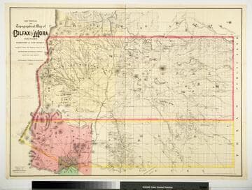
Sectional and Topographical Map of Colfax and Mora Counties Territory of New Mexico
Rare Books
Numerous changes have been made since the earlier map, 128069. "Compiled from the Original Plats in the Surveyor Generals Office Santa Fe, New Mexico. J. S. Taylor U. S. Deputy Surveyor, 1881." "Entered according to Act of Congress in the year 1882 by G.W. & C.B. Colton & Co. in the Office of the Librarian of Congress, at Washington." Prime meridian: GM. Relief: hachures. Graphic Scale: Miles. Projection: Cylindrical. Printing Process: Lithography. Verso Text: HL sticker: 128313.
128313
Image not available
Territory of Arizona
Rare Books
Complete with Indian reservations and the Grand Canyon Forest Reserve. MS note: 150213 sticker: Arizona. "Department of the Interior General Land Office Hon. Binger Hermann, Commissioner." "Compiled from the official Records of the General Land Office and other sources under the direction of Harry King, C.E. Chief of Drafting Division G.L.O." Prime meridian: GM, Washington. Relief: shaded. Graphic Scale: Miles. Projection: Polyconic. Printing Process: Lithography. Verso Text: MS notes: A5 Arizona.
150213
Image not available
Map of the Field Operations of the Army of Virginia during the Months of July and August 1862
Rare Books
"Report of Maj. Gen. John Pope to the Committee on the conduct of the War." Map printed for Supplemental report of the Joint Committee on the Conduct of the War, 1866, v.2 between pages 190 and 191. Prime meridian: GM. Relief: hachures. Projection: Plane. Printing Process: Lithography. Verso Text: HL sticker: 127420.
127420
Image not available
Territory of Utah. 1893 : Compiled from the Official Records of the General Land Office and other sources / under the supervision of Harry King, C.E. Principal Draughtsman. G.L.O
Rare Books
At head of title: "Department of the Interior, General Land Office, Hon. S. W. Lamoreux, Commissioner." Prime meridian: GM. Relief: shaded. Graphic Scale: Miles. Projection: Polyconic. Printing Process: Lithography. Verso Text: MS note: 279503, U1 Sticker: UTAH .
279503
Image not available
Siuslaw National Forest Oregon Willamette Meridian
Rare Books
MS Note "Advance copy subject to correction. Not for general distribution. C.F.B." "U. S. Department of Agriculture Forest Service 1913" Prime meridian: GM. Relief: no. Projection: Cylindrical. Printing Process: Lithography. Verso Text: HL sticker: 119337.
119337