Opening Hours
Daily: 10 A.M.–5 P.M.
Closed on Tuesdays
1151 Oxford Road
San Marino, CA 91108
Daily: 10 A.M.–5 P.M.
Closed on Tuesdays
1151 Oxford Road
San Marino, CA 91108

Image not available
Rare Books
Includes parts of Sonora, Baja California and the Southwest. Shows mines, roads, Indian tribes, etc. In green cloth covers, alt. title from cover. The Wagner collection, April 1922. In MS on map: WLB Hartley 1863. Prime meridian: GM. Relief: hachures. Graphic Scale: Miles. Projection: Polyconic. Printing Process: Lithography.
41393
Image not available
Rare Books
In four sheets. "By authority of the Forest, Fish and Game Commission, James S. Whipple, Commissioner. William F. Fox, Supt. State Forests 1908" Cadastral map shoWing public lands and adjacent private land oWnership. Inset: Railroad and county map of northern NeW York. Prime meridian: GM. Relief: shaded. Graphic Scale: Miles. Projection: Polyconic. Printing Process: Lithography. Verso Text: S.E. 1/4 MS note: Nichols.
28392
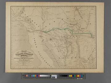
Rare Books
The map shows two probable routes of the Atlantic & Pacific Rail Road via Texas, the reason for the Gadsden Purchase. Someone has added an extension from the Colorado River to San Diego in ink. The mountains which blocked a more northerly route are clearly shown. Note on old folder: Not same as 44064 which is 1858 this map is 1854. Keep and catalog. Hand written notes and rail line to Guaymas. Prime meridian: GM. Relief: hachures. Graphic Scale: Miles. Projection: Polyconic. Printing Process: Lithography.
384988
Image not available
Rare Books
"I take great pleasure in commending this map compiled by O. B. Gunn Esqr. to the Public use as an accurate delineation of the Surveyed portions of the Territory of Kansas to this date. - I have reason to believe also that the Towns and Roads are correctly located theron, in as much as the Town sites were obtained by him from the entries at the various Land Offices and the Roads from the proper Authorities. Ward B. Burnett, Surveyor General Kansas and Nebraska. January 10, 1859." In a submap, Kansas is shown extending into present day Colorado to include the "Kansas Gold Mines." Submap: Routes from the Missouri River to the Kansas Gold Mines. MS note: 35302. Prime meridian: GM. Relief: hachures. Graphic Scale: Sections. Projection: Cylindrical. Printing Process: Lithography.
35302
Image not available
Rare Books
"Unseen California is a multi-pronged arts research initiative utilizing the University of California Natural Reserve System through site specific research performed by a collaborative artist cohort, generating opportunities for field-based arts teaching and learning, public programming, and the creation of artworks. This book features the artists' explorations in progress--their field notes--across media, generated from site work and ongoing dialogues. In this context, field notes are understood as fragments toward knowing, and these are embodied, subjective observations that might speculate and certainly express wonder, but also recognize that interpretation will often happen later, elsewhere."--Publisher's website, www.shop.theretherenow.com
642345
Image not available
Rare Books
Alt. title from cover. See also 293395 for an earlier version of this map. Prime meridian: GM. Relief: no. Graphic Scale: Miles. Projection: Cylindrical. Printing Process: Lithography.
301401